You are here: Home > Network List > TA - USArray Transportable Network (new EarthScope stations) Stations List
> Station Y18A Canyon Day Junior High, Whiteriver, AZ, USA > Earthquake Result Viewer
Y18A Canyon Day Junior High, Whiteriver, AZ, USA - Earthquake Result Viewer

| Earthquake location: |
Near West Coast Of Honshu, Japan |
| Earthquake latitude/longitude: |
37.5/138.4 |
| Earthquake time(UTC): |
2007/07/16 (197) 01:13:22 GMT |
| Earthquake Depth: |
12 km |
| Earthquake Magnitude: |
6.5 MB, 6.4 MS, 6.6 MW, 6.5 MW |
| Earthquake Catalog/Contributor: |
WHDF/NEIC |
|
| Network: |
TA USArray Transportable Network (new EarthScope stations) |
| Station: |
Y18A Canyon Day Junior High, Whiteriver, AZ, USA |
| Lat/Lon: |
33.78 N/110.03 W |
| Elevation: |
1512 m |
|
| Distance: |
84.7 deg |
| Az: |
51.098 deg |
| Baz: |
312.034 deg |
| Ray Param: |
0.04531071 |
| Estimated Moho Depth: |
34.5 km |
| Estimated Crust Vp/Vs: |
1.60 |
| Assumed Crust Vp: |
6.276 km/s |
| Estimated Crust Vs: |
3.922 km/s |
| Estimated Crust Poisson's Ratio: |
0.18 |
|
| Radial Match: |
97.10002 % |
| Radial Bump: |
361 |
| Transverse Match: |
89.282326 % |
| Transverse Bump: |
400 |
| SOD ConfigId: |
2564 |
| Insert Time: |
2010-03-06 16:14:15.237 +0000 |
| GWidth: |
2.5 |
| Max Bumps: |
400 |
| Tol: |
0.001 |
|
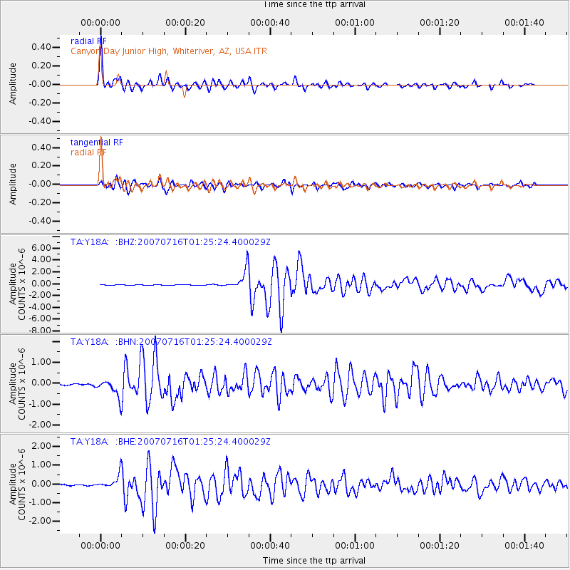
Signal To Noise
| Channel | StoN | STA | LTA |
| TA:Y18A: :BHN:20070716T01:25:24.400029Z | 8.76827 | 4.220492E-7 | 4.8133693E-8 |
| TA:Y18A: :BHE:20070716T01:25:24.400029Z | 10.411057 | 3.781166E-7 | 3.6318752E-8 |
| TA:Y18A: :BHZ:20070716T01:25:24.400029Z | 53.522247 | 1.788312E-6 | 3.34125E-8 |
| Arrivals |
| Ps | 3.4 SECOND |
| PpPs | 14 SECOND |
| PsPs/PpSs | 17 SECOND |


