You are here: Home > Network List > GS - US Geological Survey Networks Stations List
> Station KAN06 West of Argonia, Argonia, KS, USA > Earthquake Result Viewer
KAN06 West of Argonia, Argonia, KS, USA - Earthquake Result Viewer
| Earthquake location: |
Near Coast Of Northern Chile |
| Earthquake latitude/longitude: |
-26.1/-70.6 |
| Earthquake time(UTC): |
2016/07/25 (207) 17:26:49 GMT |
| Earthquake Depth: |
68 km |
| Earthquake Magnitude: |
6.2 MB |
| Earthquake Catalog/Contributor: |
NEIC PDE/NEIC COMCAT |
|
| Network: |
GS US Geological Survey Networks |
| Station: |
KAN06 West of Argonia, Argonia, KS, USA |
| Lat/Lon: |
37.25 N/97.86 W |
| Elevation: |
393 m |
|
| Distance: |
68.0 deg |
| Az: |
336.827 deg |
| Baz: |
153.679 deg |
| Ray Param: |
0.056420866 |
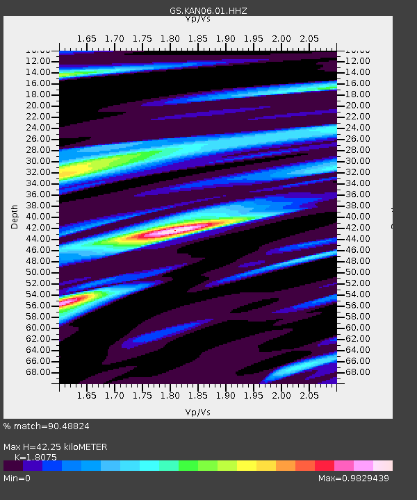
| Estimated Moho Depth: |
42.25 km |
| Estimated Crust Vp/Vs: |
1.81 |
| Assumed Crust Vp: |
6.483 km/s |
| Estimated Crust Vs: |
3.587 km/s |
| Estimated Crust Poisson's Ratio: |
0.28 |
|
| Radial Match: |
90.48824 % |
| Radial Bump: |
400 |
| Transverse Match: |
36.096 % |
| Transverse Bump: |
400 |
| SOD ConfigId: |
1634031 |
| Insert Time: |
2016-08-08 17:28:27.946 +0000 |
| GWidth: |
2.5 |
| Max Bumps: |
400 |
| Tol: |
0.001 |
|

Signal To Noise
| Channel | StoN | STA | LTA |
| GS:KAN06:01:HHZ:20160725T17:37:11.019971Z | 16.266352 | 1.6111038E-6 | 9.904519E-8 |
| GS:KAN06:01:HHN:20160725T17:37:11.019971Z | 5.1716986 | 7.2486245E-7 | 1.4015944E-7 |
| GS:KAN06:01:HHE:20160725T17:37:11.019971Z | 3.4592779 | 3.4491083E-7 | 9.9706014E-8 |
| Arrivals |
| Ps | 5.5 SECOND |
| PpPs | 18 SECOND |
| PsPs/PpSs | 23 SECOND |


