You are here: Home > Network List > TA - USArray Transportable Network (new EarthScope stations) Stations List
> Station Y18A Canyon Day Junior High, Whiteriver, AZ, USA > Earthquake Result Viewer
Y18A Canyon Day Junior High, Whiteriver, AZ, USA - Earthquake Result Viewer
| Earthquake location: |
Northern Algeria |
| Earthquake latitude/longitude: |
35.9/-0.7 |
| Earthquake time(UTC): |
2008/06/06 (158) 20:02:56 GMT |
| Earthquake Depth: |
4.0 km |
| Earthquake Magnitude: |
5.5 MB, 5.3 MS, 5.5 MW, 5.5 MW |
| Earthquake Catalog/Contributor: |
WHDF/NEIC |
|
| Network: |
TA USArray Transportable Network (new EarthScope stations) |
| Station: |
Y18A Canyon Day Junior High, Whiteriver, AZ, USA |
| Lat/Lon: |
33.78 N/110.03 W |
| Elevation: |
1512 m |
|
| Distance: |
84.3 deg |
| Az: |
307.853 deg |
| Baz: |
50.339 deg |
| Ray Param: |
0.045560066 |
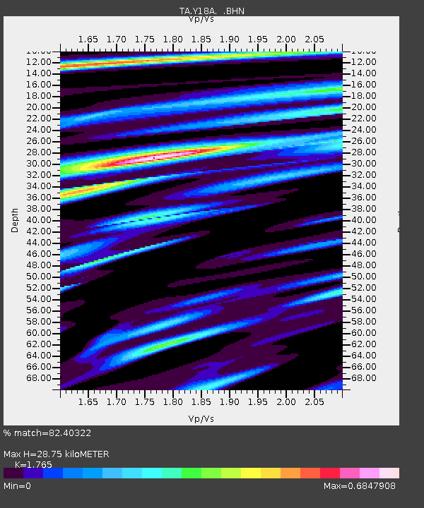
| Estimated Moho Depth: |
28.75 km |
| Estimated Crust Vp/Vs: |
1.76 |
| Assumed Crust Vp: |
6.276 km/s |
| Estimated Crust Vs: |
3.556 km/s |
| Estimated Crust Poisson's Ratio: |
0.26 |
|
| Radial Match: |
82.40322 % |
| Radial Bump: |
400 |
| Transverse Match: |
76.91052 % |
| Transverse Bump: |
400 |
| SOD ConfigId: |
2504 |
| Insert Time: |
2010-03-06 16:14:40.611 +0000 |
| GWidth: |
2.5 |
| Max Bumps: |
400 |
| Tol: |
0.001 |
|

Signal To Noise
| Channel | StoN | STA | LTA |
| TA:Y18A: :BHN:20080606T20:14:58.600022Z | 1.7811419 | 1.732119E-7 | 9.724767E-8 |
| TA:Y18A: :BHE:20080606T20:14:58.600022Z | 1.4413372 | 9.036675E-8 | 6.2696465E-8 |
| TA:Y18A: :BHZ:20080606T20:14:58.600022Z | 1.4886773 | 7.3226516E-8 | 4.918898E-8 |
| Arrivals |
| Ps | 3.6 SECOND |
| PpPs | 12 SECOND |
| PsPs/PpSs | 16 SECOND |


