You are here: Home > Network List > TA - USArray Transportable Network (new EarthScope stations) Stations List
> Station R32K Eaglecrest, AK, USA > Earthquake Result Viewer
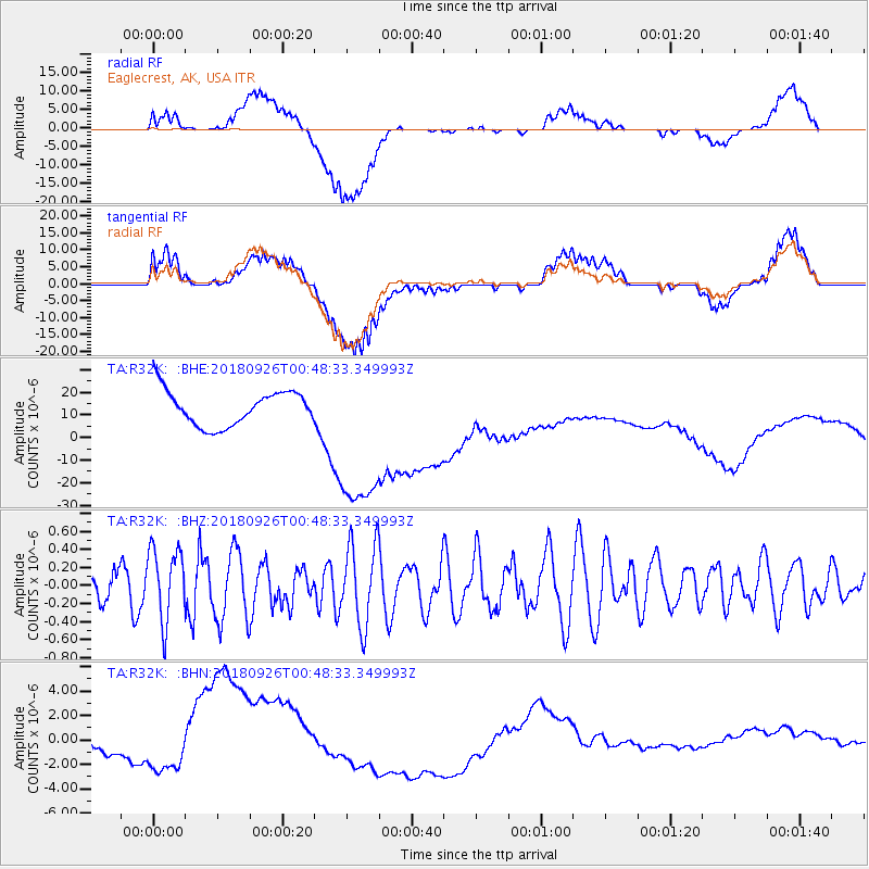
R32K Eaglecrest, AK, USA - Earthquake Result Viewer
*The percent match for this event was below the threshold and hence no stack was calculated.
| Earthquake location: |
Fiji Islands Region |
| Earthquake latitude/longitude: |
-18.0/-178.1 |
| Earthquake time(UTC): |
2018/09/26 (269) 00:37:33 GMT |
| Earthquake Depth: |
569 km |
| Earthquake Magnitude: |
5.8 Mwb |
| Earthquake Catalog/Contributor: |
NEIC PDE/us |
|
| Network: |
TA USArray Transportable Network (new EarthScope stations) |
| Station: |
R32K Eaglecrest, AK, USA |
| Lat/Lon: |
58.27 N/134.52 W |
| Elevation: |
386 m |
|
| Distance: |
84.1 deg |
| Az: |
21.486 deg |
| Baz: |
221.268 deg |
| Ray Param: |
$rayparam |
*The percent match for this event was below the threshold and hence was not used in the summary stack. |
|
| Radial Match: |
62.714607 % |
| Radial Bump: |
400 |
| Transverse Match: |
57.035416 % |
| Transverse Bump: |
400 |
| SOD ConfigId: |
13570011 |
| Insert Time: |
2019-05-01 08:16:23.244 +0000 |
| GWidth: |
2.5 |
| Max Bumps: |
400 |
| Tol: |
0.001 |
|
Signal To Noise
| Channel | StoN | STA | LTA |
| TA:R32K: :BHZ:20180926T00:48:33.349993Z | 1.4123435 | 3.947345E-7 | 2.7948903E-7 |
| TA:R32K: :BHN:20180926T00:48:33.349993Z | 0.9567417 | 8.640804E-7 | 9.0314904E-7 |
| TA:R32K: :BHE:20180926T00:48:33.349993Z | 4.899436 | 3.793885E-5 | 7.743514E-6 |
| Arrivals |
| Ps | |
| PpPs | |
| PsPs/PpSs | |


