You are here: Home > Network List > GS - US Geological Survey Networks Stations List
> Station OK038 West end E0370 Rd, Waynoka, OK, USA > Earthquake Result Viewer
OK038 West end E0370 Rd, Waynoka, OK, USA - Earthquake Result Viewer
| Earthquake location: |
Near Coast Of Northern Chile |
| Earthquake latitude/longitude: |
-26.1/-70.6 |
| Earthquake time(UTC): |
2016/07/25 (207) 17:26:49 GMT |
| Earthquake Depth: |
68 km |
| Earthquake Magnitude: |
6.2 MB |
| Earthquake Catalog/Contributor: |
NEIC PDE/NEIC COMCAT |
|
| Network: |
GS US Geological Survey Networks |
| Station: |
OK038 West end E0370 Rd, Waynoka, OK, USA |
| Lat/Lon: |
36.48 N/98.74 W |
| Elevation: |
443 m |
|
| Distance: |
67.7 deg |
| Az: |
335.77 deg |
| Baz: |
152.752 deg |
| Ray Param: |
0.0566593 |
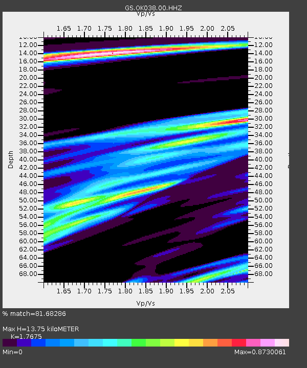
| Estimated Moho Depth: |
13.75 km |
| Estimated Crust Vp/Vs: |
1.77 |
| Assumed Crust Vp: |
6.426 km/s |
| Estimated Crust Vs: |
3.636 km/s |
| Estimated Crust Poisson's Ratio: |
0.26 |
|
| Radial Match: |
81.68286 % |
| Radial Bump: |
400 |
| Transverse Match: |
74.92231 % |
| Transverse Bump: |
400 |
| SOD ConfigId: |
1634031 |
| Insert Time: |
2016-08-08 17:28:53.591 +0000 |
| GWidth: |
2.5 |
| Max Bumps: |
400 |
| Tol: |
0.001 |
|

Signal To Noise
| Channel | StoN | STA | LTA |
| GS:OK038:00:HHZ:20160725T17:37:08.724011Z | 10.779672 | 1.346088E-6 | 1.2487281E-7 |
| GS:OK038:00:HH1:20160725T17:37:08.724011Z | 2.821649 | 6.221656E-7 | 2.2049717E-7 |
| GS:OK038:00:HH2:20160725T17:37:08.724011Z | 2.1866865 | 4.6359975E-7 | 2.1201015E-7 |
| Arrivals |
| Ps | 1.7 SECOND |
| PpPs | 5.7 SECOND |
| PsPs/PpSs | 7.4 SECOND |


