You are here: Home > Network List > YT07 - POLENET Stations List
> Station WAIS WAIS > Earthquake Result Viewer
WAIS WAIS - Earthquake Result Viewer
| Earthquake location: |
Fiji Islands Region |
| Earthquake latitude/longitude: |
-18.0/-178.1 |
| Earthquake time(UTC): |
2018/09/26 (269) 00:37:33 GMT |
| Earthquake Depth: |
569 km |
| Earthquake Magnitude: |
5.8 Mwb |
| Earthquake Catalog/Contributor: |
NEIC PDE/us |
|
| Network: |
YT POLENET |
| Station: |
WAIS WAIS |
| Lat/Lon: |
79.42 S/111.78 W |
| Elevation: |
1800 m |
|
| Distance: |
68.1 deg |
| Az: |
169.489 deg |
| Baz: |
290.084 deg |
| Ray Param: |
0.054506518 |
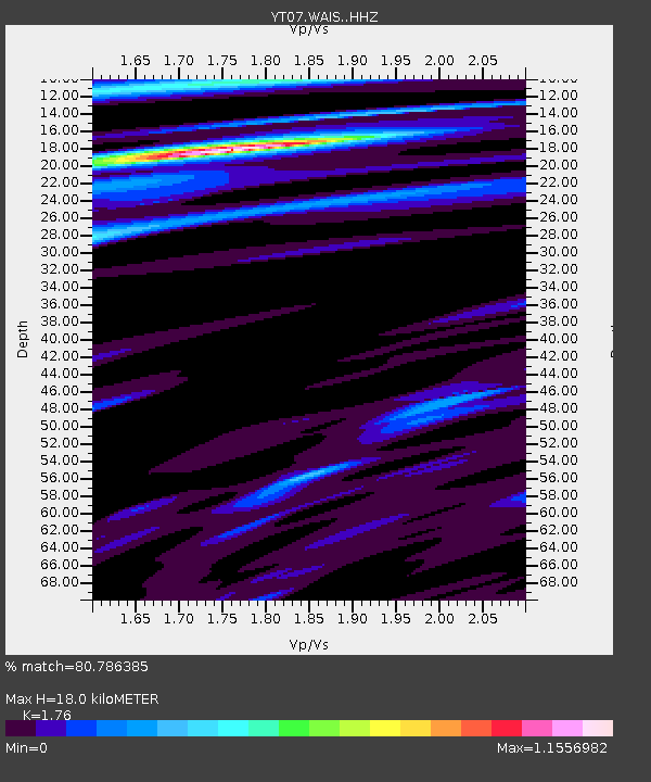
| Estimated Moho Depth: |
18.0 km |
| Estimated Crust Vp/Vs: |
1.76 |
| Assumed Crust Vp: |
5.833 km/s |
| Estimated Crust Vs: |
3.314 km/s |
| Estimated Crust Poisson's Ratio: |
0.26 |
|
| Radial Match: |
80.786385 % |
| Radial Bump: |
400 |
| Transverse Match: |
80.67468 % |
| Transverse Bump: |
400 |
| SOD ConfigId: |
13570011 |
| Insert Time: |
2019-05-01 08:17:31.837 +0000 |
| GWidth: |
2.5 |
| Max Bumps: |
400 |
| Tol: |
0.001 |
|

Signal To Noise
| Channel | StoN | STA | LTA |
| YT:WAIS: :HHZ:20180926T00:47:05.948992Z | 12.585907 | 1.7191088E-6 | 1.3658997E-7 |
| YT:WAIS: :HHN:20180926T00:47:05.948992Z | 2.0403314 | 1.9641344E-7 | 9.626545E-8 |
| YT:WAIS: :HHE:20180926T00:47:05.948992Z | 3.261808 | 2.6070157E-7 | 7.9925485E-8 |
| Arrivals |
| Ps | 2.4 SECOND |
| PpPs | 8.3 SECOND |
| PsPs/PpSs | 11 SECOND |


