You are here: Home > Network List > CI - Caltech Regional Seismic Network Stations List
> Station LRL Laurel Mtn Radio Fac, Ridgecrest, CA, USA > Earthquake Result Viewer
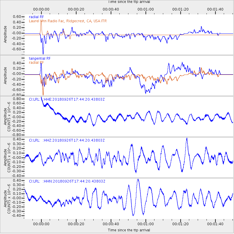
LRL Laurel Mtn Radio Fac, Ridgecrest, CA, USA - Earthquake Result Viewer
*The percent match for this event was below the threshold and hence no stack was calculated.
| Earthquake location: |
Southern East Pacific Rise |
| Earthquake latitude/longitude: |
-34.9/-107.6 |
| Earthquake time(UTC): |
2018/09/26 (269) 17:33:35 GMT |
| Earthquake Depth: |
10 km |
| Earthquake Magnitude: |
5.7 Mww |
| Earthquake Catalog/Contributor: |
NEIC PDE/us |
|
| Network: |
CI Caltech Regional Seismic Network |
| Station: |
LRL Laurel Mtn Radio Fac, Ridgecrest, CA, USA |
| Lat/Lon: |
35.48 N/117.68 W |
| Elevation: |
1340 m |
|
| Distance: |
70.7 deg |
| Az: |
351.299 deg |
| Baz: |
171.242 deg |
| Ray Param: |
$rayparam |
*The percent match for this event was below the threshold and hence was not used in the summary stack. |
|
| Radial Match: |
57.922245 % |
| Radial Bump: |
400 |
| Transverse Match: |
59.114315 % |
| Transverse Bump: |
400 |
| SOD ConfigId: |
13570011 |
| Insert Time: |
2019-05-01 08:19:18.101 +0000 |
| GWidth: |
2.5 |
| Max Bumps: |
400 |
| Tol: |
0.001 |
|
Signal To Noise
| Channel | StoN | STA | LTA |
| CI:LRL: :HHZ:20180926T17:44:20.43803Z | 1.2457719 | 8.762268E-8 | 7.033606E-8 |
| CI:LRL: :HHN:20180926T17:44:20.43803Z | 1.8536421 | 1.8321808E-7 | 9.8842214E-8 |
| CI:LRL: :HHE:20180926T17:44:20.43803Z | 1.0941695 | 3.0626038E-7 | 2.799021E-7 |
| Arrivals |
| Ps | |
| PpPs | |
| PsPs/PpSs | |


