You are here: Home > Network List > CI - Caltech Regional Seismic Network Stations List
> Station MPP McPhearson Peak > Earthquake Result Viewer
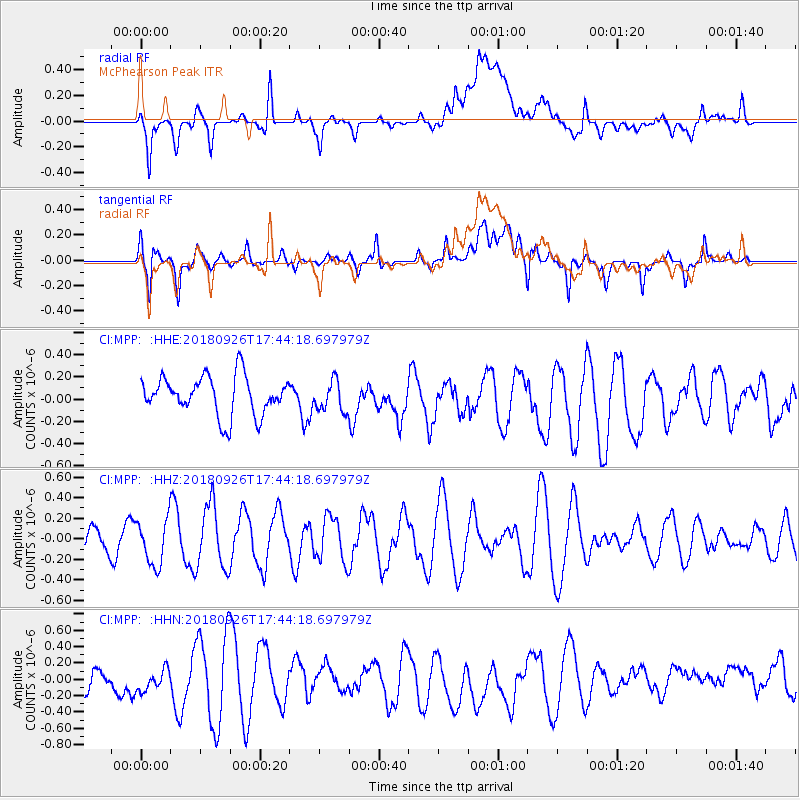
MPP McPhearson Peak - Earthquake Result Viewer
*The percent match for this event was below the threshold and hence no stack was calculated.
| Earthquake location: |
Southern East Pacific Rise |
| Earthquake latitude/longitude: |
-34.9/-107.6 |
| Earthquake time(UTC): |
2018/09/26 (269) 17:33:35 GMT |
| Earthquake Depth: |
10 km |
| Earthquake Magnitude: |
5.7 Mww |
| Earthquake Catalog/Contributor: |
NEIC PDE/us |
|
| Network: |
CI Caltech Regional Seismic Network |
| Station: |
MPP McPhearson Peak |
| Lat/Lon: |
34.89 N/119.81 W |
| Elevation: |
1739 m |
|
| Distance: |
70.4 deg |
| Az: |
349.369 deg |
| Baz: |
169.376 deg |
| Ray Param: |
$rayparam |
*The percent match for this event was below the threshold and hence was not used in the summary stack. |
|
| Radial Match: |
56.430737 % |
| Radial Bump: |
400 |
| Transverse Match: |
56.110226 % |
| Transverse Bump: |
400 |
| SOD ConfigId: |
13570011 |
| Insert Time: |
2019-05-01 08:19:19.735 +0000 |
| GWidth: |
2.5 |
| Max Bumps: |
400 |
| Tol: |
0.001 |
|
Signal To Noise
| Channel | StoN | STA | LTA |
| CI:MPP: :HHZ:20180926T17:44:18.697979Z | 1.2188857 | 2.226494E-7 | 1.8266635E-7 |
| CI:MPP: :HHN:20180926T17:44:18.697979Z | 0.9654326 | 2.2314279E-7 | 2.3113245E-7 |
| CI:MPP: :HHE:20180926T17:44:18.697979Z | 0.78242105 | 1.3647073E-7 | 1.7442109E-7 |
| Arrivals |
| Ps | |
| PpPs | |
| PsPs/PpSs | |


