You are here: Home > Network List > TA - USArray Transportable Network (new EarthScope stations) Stations List
> Station Y18A Canyon Day Junior High, Whiteriver, AZ, USA > Earthquake Result Viewer
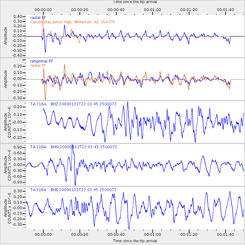
Y18A Canyon Day Junior High, Whiteriver, AZ, USA - Earthquake Result Viewer
*The percent match for this event was below the threshold and hence no stack was calculated.
| Earthquake location: |
Near East Coast Of Honshu, Japan |
| Earthquake latitude/longitude: |
36.7/141.1 |
| Earthquake time(UTC): |
2009/01/31 (031) 21:51:52 GMT |
| Earthquake Depth: |
34 km |
| Earthquake Magnitude: |
5.6 MB, 5.3 MS, 5.8 MW, 5.7 MW |
| Earthquake Catalog/Contributor: |
WHDF/NEIC |
|
| Network: |
TA USArray Transportable Network (new EarthScope stations) |
| Station: |
Y18A Canyon Day Junior High, Whiteriver, AZ, USA |
| Lat/Lon: |
33.78 N/110.03 W |
| Elevation: |
1512 m |
|
| Distance: |
83.5 deg |
| Az: |
52.517 deg |
| Baz: |
310.048 deg |
| Ray Param: |
$rayparam |
*The percent match for this event was below the threshold and hence was not used in the summary stack. |
|
| Radial Match: |
60.573086 % |
| Radial Bump: |
400 |
| Transverse Match: |
53.087826 % |
| Transverse Bump: |
400 |
| SOD ConfigId: |
2658 |
| Insert Time: |
2010-03-06 16:15:43.168 +0000 |
| GWidth: |
2.5 |
| Max Bumps: |
400 |
| Tol: |
0.001 |
|
Signal To Noise
| Channel | StoN | STA | LTA |
| TA:Y18A: :BHN:20090131T22:03:45.250007Z | 2.9389396 | 2.1688001E-7 | 7.379533E-8 |
| TA:Y18A: :BHE:20090131T22:03:45.250007Z | 1.0735955 | 7.602921E-8 | 7.0817364E-8 |
| TA:Y18A: :BHZ:20090131T22:03:45.250007Z | 1.8978422 | 1.2589169E-7 | 6.6334124E-8 |
| Arrivals |
| Ps | |
| PpPs | |
| PsPs/PpSs | |


