You are here: Home > Network List > TA - USArray Transportable Network (new EarthScope stations) Stations List
> Station Y18A Canyon Day Junior High, Whiteriver, AZ, USA > Earthquake Result Viewer
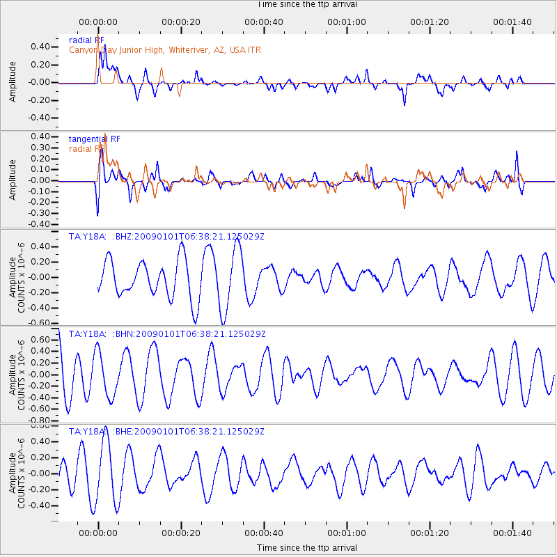
Y18A Canyon Day Junior High, Whiteriver, AZ, USA - Earthquake Result Viewer
*The percent match for this event was below the threshold and hence no stack was calculated.
| Earthquake location: |
Southern East Pacific Rise |
| Earthquake latitude/longitude: |
-34.8/-107.6 |
| Earthquake time(UTC): |
2009/01/01 (001) 06:27:51 GMT |
| Earthquake Depth: |
10 km |
| Earthquake Magnitude: |
5.8 MW, 5.2 MS, 5.1 MB, 5.8 MW |
| Earthquake Catalog/Contributor: |
WHDF/NEIC |
|
| Network: |
TA USArray Transportable Network (new EarthScope stations) |
| Station: |
Y18A Canyon Day Junior High, Whiteriver, AZ, USA |
| Lat/Lon: |
33.78 N/110.03 W |
| Elevation: |
1512 m |
|
| Distance: |
68.3 deg |
| Az: |
357.86 deg |
| Baz: |
177.887 deg |
| Ray Param: |
$rayparam |
*The percent match for this event was below the threshold and hence was not used in the summary stack. |
|
| Radial Match: |
53.672997 % |
| Radial Bump: |
400 |
| Transverse Match: |
48.542862 % |
| Transverse Bump: |
400 |
| SOD ConfigId: |
2834 |
| Insert Time: |
2010-03-06 16:16:06.146 +0000 |
| GWidth: |
2.5 |
| Max Bumps: |
400 |
| Tol: |
0.001 |
|
Signal To Noise
| Channel | StoN | STA | LTA |
| TA:Y18A: :BHN:20090101T06:38:21.125029Z | 0.924153 | 3.824858E-7 | 4.1387716E-7 |
| TA:Y18A: :BHE:20090101T06:38:21.125029Z | 1.4466853 | 3.9610256E-7 | 2.7380008E-7 |
| TA:Y18A: :BHZ:20090101T06:38:21.125029Z | 1.7513835 | 4.228723E-7 | 2.414504E-7 |
| Arrivals |
| Ps | |
| PpPs | |
| PsPs/PpSs | |


