You are here: Home > Network List > TA - USArray Transportable Network (new EarthScope stations) Stations List
> Station G31M Satah River, YT, CAN > Earthquake Result Viewer
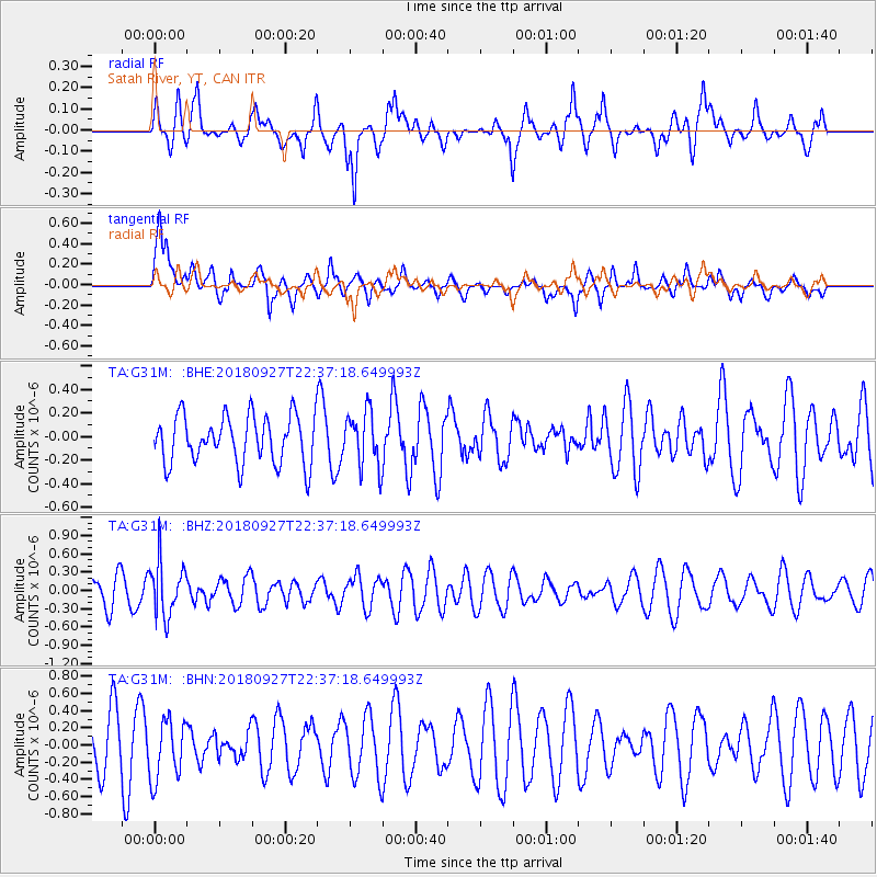
G31M Satah River, YT, CAN - Earthquake Result Viewer
*The percent match for this event was below the threshold and hence no stack was calculated.
| Earthquake location: |
Fiji Islands Region |
| Earthquake latitude/longitude: |
-18.2/-178.2 |
| Earthquake time(UTC): |
2018/09/27 (270) 22:25:43 GMT |
| Earthquake Depth: |
540 km |
| Earthquake Magnitude: |
5.5 Mww |
| Earthquake Catalog/Contributor: |
NEIC PDE/us |
|
| Network: |
TA USArray Transportable Network (new EarthScope stations) |
| Station: |
G31M Satah River, YT, CAN |
| Lat/Lon: |
66.92 N/134.27 W |
| Elevation: |
61 m |
|
| Distance: |
90.9 deg |
| Az: |
15.886 deg |
| Baz: |
221.316 deg |
| Ray Param: |
$rayparam |
*The percent match for this event was below the threshold and hence was not used in the summary stack. |
|
| Radial Match: |
52.959522 % |
| Radial Bump: |
400 |
| Transverse Match: |
66.887436 % |
| Transverse Bump: |
386 |
| SOD ConfigId: |
13570011 |
| Insert Time: |
2019-05-01 08:33:41.678 +0000 |
| GWidth: |
2.5 |
| Max Bumps: |
400 |
| Tol: |
0.001 |
|
Signal To Noise
| Channel | StoN | STA | LTA |
| TA:G31M: :BHZ:20180927T22:37:18.649993Z | 2.2554142 | 4.4297698E-7 | 1.9640603E-7 |
| TA:G31M: :BHN:20180927T22:37:18.649993Z | 1.120612 | 3.5314852E-7 | 3.1513898E-7 |
| TA:G31M: :BHE:20180927T22:37:18.649993Z | 1.1411797 | 2.2940287E-7 | 2.0102257E-7 |
| Arrivals |
| Ps | |
| PpPs | |
| PsPs/PpSs | |


