You are here: Home > Network List > TA - USArray Transportable Network (new EarthScope stations) Stations List
> Station P23A Jefferson, CO, USA > Earthquake Result Viewer
P23A Jefferson, CO, USA - Earthquake Result Viewer
| Earthquake location: |
Tonga Islands |
| Earthquake latitude/longitude: |
-21.9/-173.8 |
| Earthquake time(UTC): |
2008/10/19 (293) 05:10:33 GMT |
| Earthquake Depth: |
29 km |
| Earthquake Magnitude: |
6.8 MB, 7.0 MS, 6.9 MW, 6.9 MW |
| Earthquake Catalog/Contributor: |
WHDF/NEIC |
|
| Network: |
TA USArray Transportable Network (new EarthScope stations) |
| Station: |
P23A Jefferson, CO, USA |
| Lat/Lon: |
39.37 N/105.84 W |
| Elevation: |
3006 m |
|
| Distance: |
87.9 deg |
| Az: |
45.975 deg |
| Baz: |
239.512 deg |
| Ray Param: |
0.042925365 |
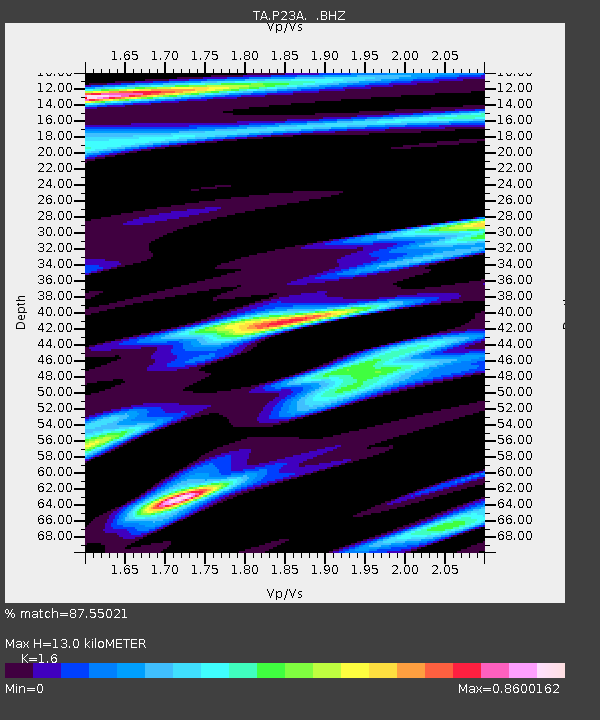
| Estimated Moho Depth: |
13.0 km |
| Estimated Crust Vp/Vs: |
1.60 |
| Assumed Crust Vp: |
6.159 km/s |
| Estimated Crust Vs: |
3.849 km/s |
| Estimated Crust Poisson's Ratio: |
0.18 |
|
| Radial Match: |
87.55021 % |
| Radial Bump: |
400 |
| Transverse Match: |
77.093834 % |
| Transverse Bump: |
400 |
| SOD ConfigId: |
2556 |
| Insert Time: |
2010-03-06 16:16:24.530 +0000 |
| GWidth: |
2.5 |
| Max Bumps: |
400 |
| Tol: |
0.001 |
|

Signal To Noise
| Channel | StoN | STA | LTA |
| TA:P23A: :BHZ:20081019T05:22:49.550015Z | 21.505493 | 4.436668E-6 | 2.0630392E-7 |
| TA:P23A: :BHN:20081019T05:22:49.550015Z | 3.2279387 | 6.4333045E-7 | 1.993007E-7 |
| TA:P23A: :BHE:20081019T05:22:49.550015Z | 2.436801 | 1.0566621E-6 | 4.3362678E-7 |
| Arrivals |
| Ps | 1.3 SECOND |
| PpPs | 5.4 SECOND |
| PsPs/PpSs | 6.7 SECOND |


