You are here: Home > Network List > TA - USArray Transportable Network (new EarthScope stations) Stations List
> Station P23A Jefferson, CO, USA > Earthquake Result Viewer
P23A Jefferson, CO, USA - Earthquake Result Viewer
| Earthquake location: |
Northern Mid-Atlantic Ridge |
| Earthquake latitude/longitude: |
23.9/-46.1 |
| Earthquake time(UTC): |
2009/06/06 (157) 20:33:28 GMT |
| Earthquake Depth: |
14 km |
| Earthquake Magnitude: |
6.0 MB, 5.7 MS, 6.0 MW, 6.0 MW |
| Earthquake Catalog/Contributor: |
WHDF/NEIC |
|
| Network: |
TA USArray Transportable Network (new EarthScope stations) |
| Station: |
P23A Jefferson, CO, USA |
| Lat/Lon: |
39.37 N/105.84 W |
| Elevation: |
3006 m |
|
| Distance: |
52.3 deg |
| Az: |
302.182 deg |
| Baz: |
88.531 deg |
| Ray Param: |
0.06685272 |
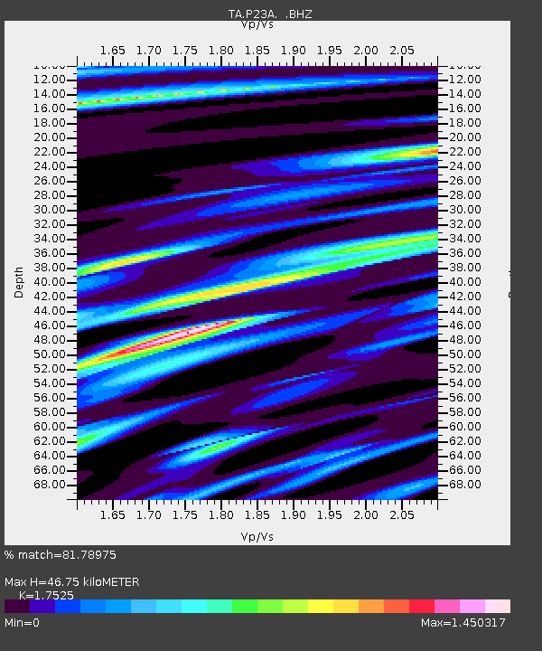
| Estimated Moho Depth: |
46.75 km |
| Estimated Crust Vp/Vs: |
1.75 |
| Assumed Crust Vp: |
6.159 km/s |
| Estimated Crust Vs: |
3.514 km/s |
| Estimated Crust Poisson's Ratio: |
0.26 |
|
| Radial Match: |
81.78975 % |
| Radial Bump: |
400 |
| Transverse Match: |
71.429405 % |
| Transverse Bump: |
400 |
| SOD ConfigId: |
2648 |
| Insert Time: |
2010-03-06 16:16:48.568 +0000 |
| GWidth: |
2.5 |
| Max Bumps: |
400 |
| Tol: |
0.001 |
|

Signal To Noise
| Channel | StoN | STA | LTA |
| TA:P23A: :BHZ:20090606T20:42:08.650007Z | 3.7256966 | 5.215498E-7 | 1.399872E-7 |
| TA:P23A: :BHN:20090606T20:42:08.650007Z | 1.2356 | 2.765941E-7 | 2.238541E-7 |
| TA:P23A: :BHE:20090606T20:42:08.650007Z | 1.3111836 | 4.339875E-7 | 3.3098914E-7 |
| Arrivals |
| Ps | 6.0 SECOND |
| PpPs | 20 SECOND |
| PsPs/PpSs | 26 SECOND |


