You are here: Home > Network List > TA - USArray Transportable Network (new EarthScope stations) Stations List
> Station P23A Jefferson, CO, USA > Earthquake Result Viewer
P23A Jefferson, CO, USA - Earthquake Result Viewer
| Earthquake location: |
Costa Rica |
| Earthquake latitude/longitude: |
8.5/-83.2 |
| Earthquake time(UTC): |
2009/03/11 (070) 17:24:36 GMT |
| Earthquake Depth: |
14 km |
| Earthquake Magnitude: |
5.8 MB, 5.6 MS, 5.9 MW, 5.9 MW |
| Earthquake Catalog/Contributor: |
WHDF/NEIC |
|
| Network: |
TA USArray Transportable Network (new EarthScope stations) |
| Station: |
P23A Jefferson, CO, USA |
| Lat/Lon: |
39.37 N/105.84 W |
| Elevation: |
3006 m |
|
| Distance: |
36.8 deg |
| Az: |
330.168 deg |
| Baz: |
140.592 deg |
| Ray Param: |
0.076463774 |
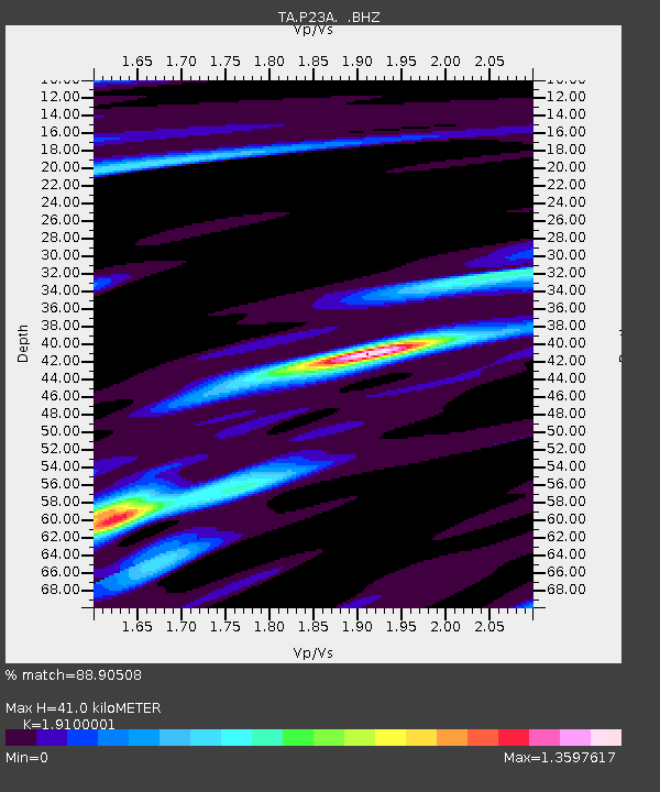
| Estimated Moho Depth: |
41.0 km |
| Estimated Crust Vp/Vs: |
1.91 |
| Assumed Crust Vp: |
6.159 km/s |
| Estimated Crust Vs: |
3.224 km/s |
| Estimated Crust Poisson's Ratio: |
0.31 |
|
| Radial Match: |
88.90508 % |
| Radial Bump: |
371 |
| Transverse Match: |
66.36095 % |
| Transverse Bump: |
400 |
| SOD ConfigId: |
2658 |
| Insert Time: |
2010-03-06 16:16:49.766 +0000 |
| GWidth: |
2.5 |
| Max Bumps: |
400 |
| Tol: |
0.001 |
|

Signal To Noise
| Channel | StoN | STA | LTA |
| TA:P23A: :BHZ:20090311T17:31:13.224014Z | 3.0141108 | 7.40616E-7 | 2.4571625E-7 |
| TA:P23A: :BHN:20090311T17:31:13.224014Z | 2.6142104 | 4.6734147E-7 | 1.7876965E-7 |
| TA:P23A: :BHE:20090311T17:31:13.224014Z | 0.69080174 | 1.7112576E-7 | 2.4772052E-7 |
| Arrivals |
| Ps | 6.4 SECOND |
| PpPs | 18 SECOND |
| PsPs/PpSs | 25 SECOND |


