You are here: Home > Network List > TA - USArray Transportable Network (new EarthScope stations) Stations List
> Station P23A Jefferson, CO, USA > Earthquake Result Viewer
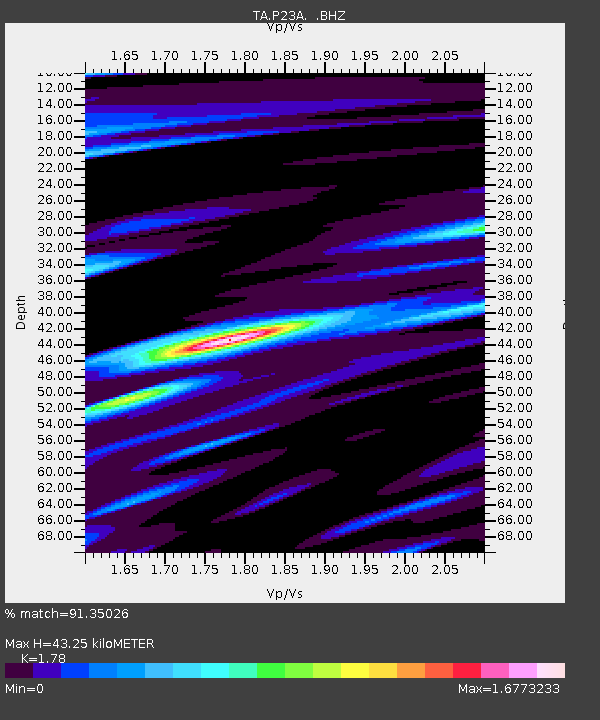
P23A Jefferson, CO, USA - Earthquake Result Viewer
| Earthquake location: |
Panama |
| Earthquake latitude/longitude: |
9.6/-79.0 |
| Earthquake time(UTC): |
2009/07/04 (185) 06:49:35 GMT |
| Earthquake Depth: |
38 km |
| Earthquake Magnitude: |
6.0 MB, 5.5 MS, 6.0 MW, 6.0 MW |
| Earthquake Catalog/Contributor: |
WHDF/NEIC |
|
| Network: |
TA USArray Transportable Network (new EarthScope stations) |
| Station: |
P23A Jefferson, CO, USA |
| Lat/Lon: |
39.37 N/105.84 W |
| Elevation: |
3006 m |
|
| Distance: |
38.1 deg |
| Az: |
325.443 deg |
| Baz: |
133.804 deg |
| Ray Param: |
0.07564864 |
| Estimated Moho Depth: |
43.25 km |
| Estimated Crust Vp/Vs: |
1.78 |
| Assumed Crust Vp: |
6.159 km/s |
| Estimated Crust Vs: |
3.46 km/s |
| Estimated Crust Poisson's Ratio: |
0.27 |
|
| Radial Match: |
91.35026 % |
| Radial Bump: |
400 |
| Transverse Match: |
70.09266 % |
| Transverse Bump: |
400 |
| SOD ConfigId: |
2648 |
| Insert Time: |
2010-03-06 16:16:51.982 +0000 |
| GWidth: |
2.5 |
| Max Bumps: |
400 |
| Tol: |
0.001 |
|

Signal To Noise
| Channel | StoN | STA | LTA |
| TA:P23A: :BHZ:20090704T06:56:20.700002Z | 12.506955 | 9.198164E-7 | 7.354439E-8 |
| TA:P23A: :BHN:20090704T06:56:20.700002Z | 3.1538842 | 2.8495182E-7 | 9.034949E-8 |
| TA:P23A: :BHE:20090704T06:56:20.700002Z | 5.0351157 | 3.3646373E-7 | 6.682344E-8 |
| Arrivals |
| Ps | 5.9 SECOND |
| PpPs | 18 SECOND |
| PsPs/PpSs | 24 SECOND |


