You are here: Home > Network List > TA - USArray Transportable Network (new EarthScope stations) Stations List
> Station C16K Lisburne Hills, AK, USA > Earthquake Result Viewer
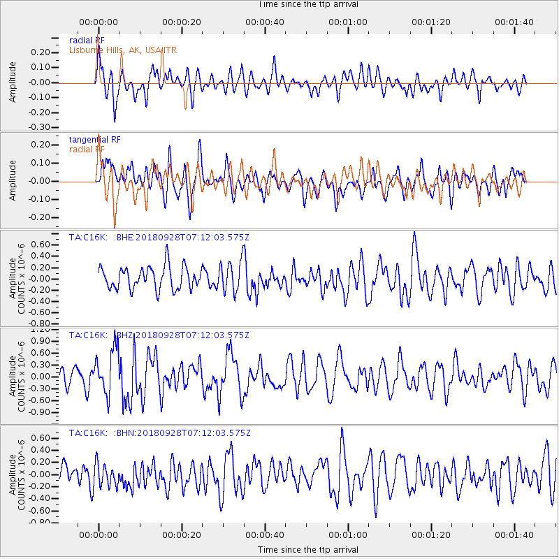
C16K Lisburne Hills, AK, USA - Earthquake Result Viewer
*The percent match for this event was below the threshold and hence no stack was calculated.
| Earthquake location: |
Minahassa Peninsula, Sulawesi |
| Earthquake latitude/longitude: |
-0.4/119.8 |
| Earthquake time(UTC): |
2018/09/28 (271) 07:00:01 GMT |
| Earthquake Depth: |
18 km |
| Earthquake Magnitude: |
6.1 Mww |
| Earthquake Catalog/Contributor: |
NEIC PDE/us |
|
| Network: |
TA USArray Transportable Network (new EarthScope stations) |
| Station: |
C16K Lisburne Hills, AK, USA |
| Lat/Lon: |
68.27 N/165.34 W |
| Elevation: |
102 m |
|
| Distance: |
84.8 deg |
| Az: |
21.157 deg |
| Baz: |
255.791 deg |
| Ray Param: |
$rayparam |
*The percent match for this event was below the threshold and hence was not used in the summary stack. |
|
| Radial Match: |
55.695244 % |
| Radial Bump: |
400 |
| Transverse Match: |
49.571873 % |
| Transverse Bump: |
400 |
| SOD ConfigId: |
13570011 |
| Insert Time: |
2019-05-01 08:42:30.717 +0000 |
| GWidth: |
2.5 |
| Max Bumps: |
400 |
| Tol: |
0.001 |
|
Signal To Noise
| Channel | StoN | STA | LTA |
| TA:C16K: :BHZ:20180928T07:12:03.575Z | 2.76889 | 5.922442E-7 | 2.1389228E-7 |
| TA:C16K: :BHN:20180928T07:12:03.575Z | 0.99746287 | 1.912627E-7 | 1.917492E-7 |
| TA:C16K: :BHE:20180928T07:12:03.575Z | 1.4496278 | 2.8510345E-7 | 1.9667355E-7 |
| Arrivals |
| Ps | |
| PpPs | |
| PsPs/PpSs | |


