You are here: Home > Network List > TA - USArray Transportable Network (new EarthScope stations) Stations List
> Station G16K Koyuk River, AK, USA > Earthquake Result Viewer
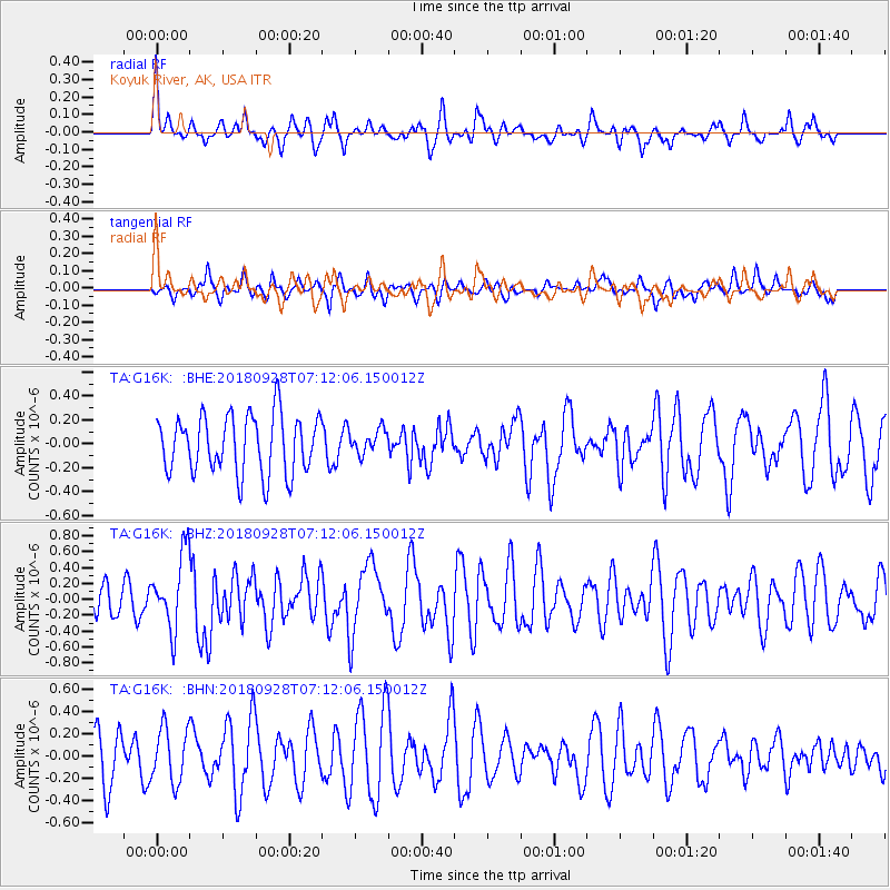
G16K Koyuk River, AK, USA - Earthquake Result Viewer
*The percent match for this event was below the threshold and hence no stack was calculated.
| Earthquake location: |
Minahassa Peninsula, Sulawesi |
| Earthquake latitude/longitude: |
-0.4/119.8 |
| Earthquake time(UTC): |
2018/09/28 (271) 07:00:01 GMT |
| Earthquake Depth: |
18 km |
| Earthquake Magnitude: |
6.1 Mww |
| Earthquake Catalog/Contributor: |
NEIC PDE/us |
|
| Network: |
TA USArray Transportable Network (new EarthScope stations) |
| Station: |
G16K Koyuk River, AK, USA |
| Lat/Lon: |
65.39 N/162.35 W |
| Elevation: |
169 m |
|
| Distance: |
85.3 deg |
| Az: |
24.251 deg |
| Baz: |
258.804 deg |
| Ray Param: |
$rayparam |
*The percent match for this event was below the threshold and hence was not used in the summary stack. |
|
| Radial Match: |
61.119366 % |
| Radial Bump: |
365 |
| Transverse Match: |
32.885075 % |
| Transverse Bump: |
312 |
| SOD ConfigId: |
13570011 |
| Insert Time: |
2019-05-01 08:42:39.455 +0000 |
| GWidth: |
2.5 |
| Max Bumps: |
400 |
| Tol: |
0.001 |
|
Signal To Noise
| Channel | StoN | STA | LTA |
| TA:G16K: :BHZ:20180928T07:12:06.150012Z | 1.9035875 | 4.7317351E-7 | 2.4856936E-7 |
| TA:G16K: :BHN:20180928T07:12:06.150012Z | 0.9373369 | 2.431972E-7 | 2.594555E-7 |
| TA:G16K: :BHE:20180928T07:12:06.150012Z | 0.40772495 | 9.9226966E-8 | 2.4336742E-7 |
| Arrivals |
| Ps | |
| PpPs | |
| PsPs/PpSs | |


