You are here: Home > Network List > TS - TERRAscope (Southern California Seismic Network) Stations List
> Station BAR Barrett Dam, California, USA > Earthquake Result Viewer
BAR Barrett Dam, California, USA - Earthquake Result Viewer
| Earthquake location: |
Near East Coast Of Kamchatka |
| Earthquake latitude/longitude: |
51.9/158.7 |
| Earthquake time(UTC): |
1993/11/13 (317) 01:18:04 GMT |
| Earthquake Depth: |
34 km |
| Earthquake Magnitude: |
6.5 MB, 7.1 MS, 6.9 UNKNOWN |
| Earthquake Catalog/Contributor: |
WHDF/NEIC |
|
| Network: |
TS TERRAscope (Southern California Seismic Network) |
| Station: |
BAR Barrett Dam, California, USA |
| Lat/Lon: |
32.68 N/116.67 W |
| Elevation: |
548 m |
|
| Distance: |
61.9 deg |
| Az: |
72.125 deg |
| Baz: |
315.658 deg |
| Ray Param: |
0.06051684 |
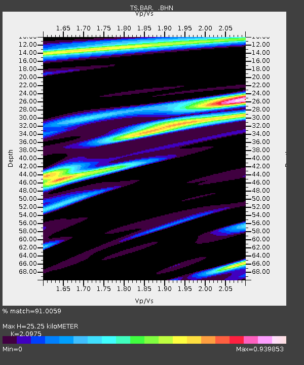
| Estimated Moho Depth: |
25.25 km |
| Estimated Crust Vp/Vs: |
2.10 |
| Assumed Crust Vp: |
6.264 km/s |
| Estimated Crust Vs: |
2.986 km/s |
| Estimated Crust Poisson's Ratio: |
0.35 |
|
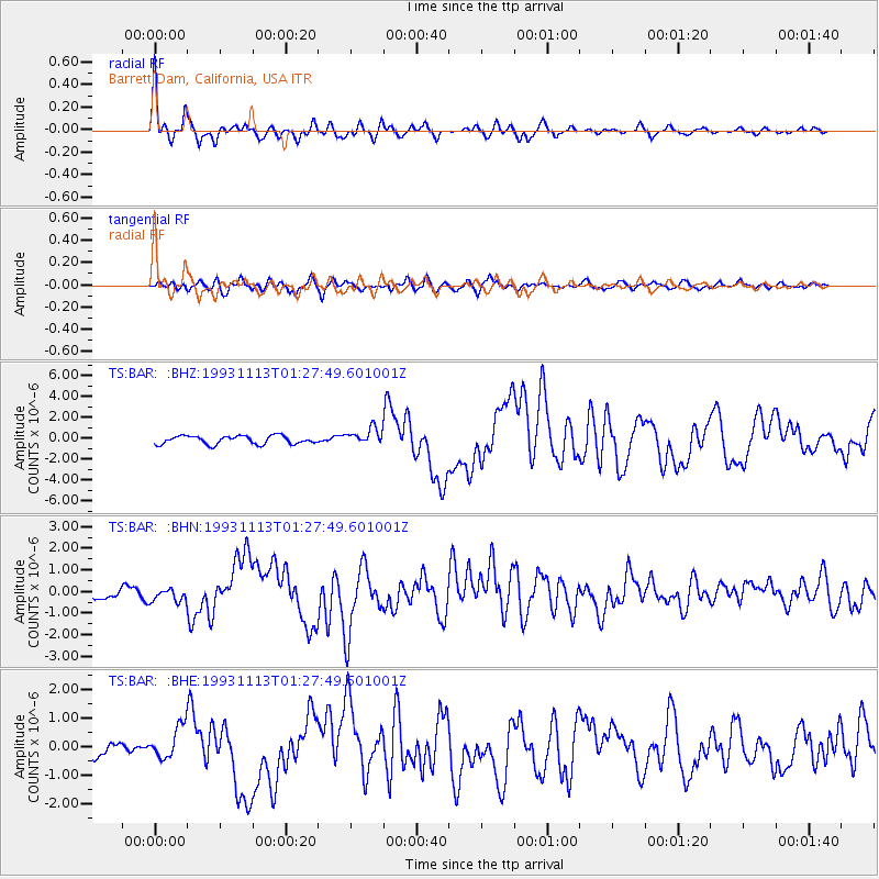
| Radial Match: |
91.0059 % |
| Radial Bump: |
400 |
| Transverse Match: |
72.37985 % |
| Transverse Bump: |
400 |
| SOD ConfigId: |
16938 |
| Insert Time: |
2010-02-26 13:57:07.178 +0000 |
| GWidth: |
2.5 |
| Max Bumps: |
400 |
| Tol: |
0.001 |
|
Signal To Noise
| Channel | StoN | STA | LTA |
| TS:BAR: :BHN:19931113T01:27:49.601001Z | 0.87463844 | 3.1283903E-7 | 3.5767812E-7 |
| TS:BAR: :BHE:19931113T01:27:49.601001Z | 1.7853267 | 5.67857E-7 | 3.1806894E-7 |
| TS:BAR: :BHZ:19931113T01:27:49.601001Z | 1.944736 | 7.7564954E-7 | 3.9884566E-7 |
| Arrivals |
| Ps | 4.6 SECOND |
| PpPs | 12 SECOND |
| PsPs/PpSs | 17 SECOND |


