You are here: Home > Network List > 2H - Interim Broadband Monitoring of the Mount Erebus Volcano Stations List
> Station ELHT Mt Erebus site ELHT > Earthquake Result Viewer
ELHT Mt Erebus site ELHT - Earthquake Result Viewer
| Earthquake location: |
Minahassa Peninsula, Sulawesi |
| Earthquake latitude/longitude: |
-0.2/119.8 |
| Earthquake time(UTC): |
2018/09/28 (271) 10:02:43 GMT |
| Earthquake Depth: |
10 km |
| Earthquake Magnitude: |
7.5 Mww |
| Earthquake Catalog/Contributor: |
NEIC PDE/us |
|
| Network: |
2H Interim Broadband Monitoring of the Mount Erebus Volcano |
| Station: |
ELHT Mt Erebus site ELHT |
| Lat/Lon: |
77.51 S/167.14 E |
| Elevation: |
3375 m |
|
| Distance: |
81.3 deg |
| Az: |
170.688 deg |
| Baz: |
311.975 deg |
| Ray Param: |
0.0476568 |
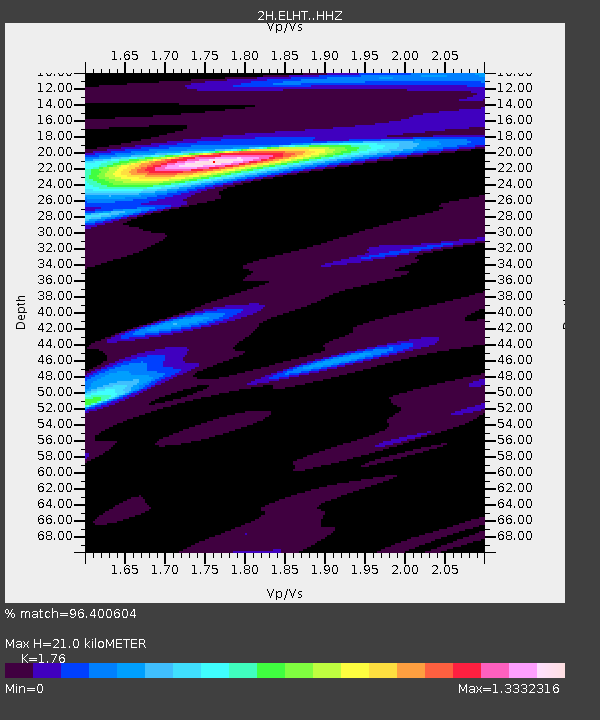
| Estimated Moho Depth: |
21.0 km |
| Estimated Crust Vp/Vs: |
1.76 |
| Assumed Crust Vp: |
6.183 km/s |
| Estimated Crust Vs: |
3.513 km/s |
| Estimated Crust Poisson's Ratio: |
0.26 |
|
| Radial Match: |
96.400604 % |
| Radial Bump: |
385 |
| Transverse Match: |
79.898224 % |
| Transverse Bump: |
400 |
| SOD ConfigId: |
13570011 |
| Insert Time: |
2019-05-01 08:47:04.262 +0000 |
| GWidth: |
2.5 |
| Max Bumps: |
400 |
| Tol: |
0.001 |
|

Signal To Noise
| Channel | StoN | STA | LTA |
| 2H:ELHT: :HHZ:20180928T10:14:28.633992Z | 3.9852445 | 7.027357E-7 | 1.763344E-7 |
| 2H:ELHT: :HH1:20180928T10:14:28.633992Z | 3.2026534 | 4.1619495E-7 | 1.2995316E-7 |
| 2H:ELHT: :HH2:20180928T10:14:28.633992Z | 1.2465942 | 3.073617E-7 | 2.4656114E-7 |
| Arrivals |
| Ps | 2.6 SECOND |
| PpPs | 9.1 SECOND |
| PsPs/PpSs | 12 SECOND |


