You are here: Home > Network List > AK - Alaska Regional Network Stations List
> Station GAMB Gambell Broadband > Earthquake Result Viewer
GAMB Gambell Broadband - Earthquake Result Viewer
| Earthquake location: |
Minahassa Peninsula, Sulawesi |
| Earthquake latitude/longitude: |
-0.2/119.8 |
| Earthquake time(UTC): |
2018/09/28 (271) 10:02:43 GMT |
| Earthquake Depth: |
10 km |
| Earthquake Magnitude: |
7.5 Mww |
| Earthquake Catalog/Contributor: |
NEIC PDE/us |
|
| Network: |
AK Alaska Regional Network |
| Station: |
GAMB Gambell Broadband |
| Lat/Lon: |
63.78 N/171.70 W |
| Elevation: |
10 m |
|
| Distance: |
80.8 deg |
| Az: |
24.749 deg |
| Baz: |
250.449 deg |
| Ray Param: |
0.048049554 |
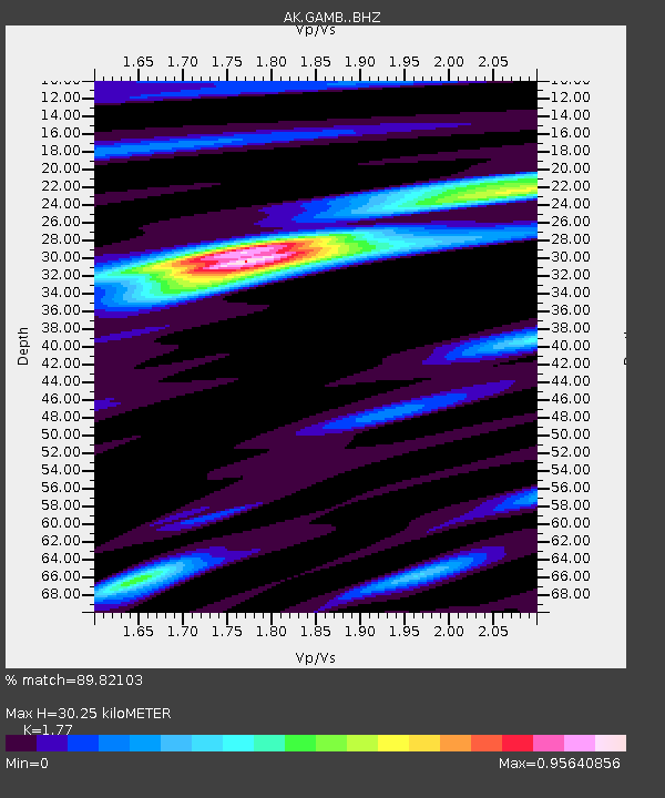
| Estimated Moho Depth: |
30.25 km |
| Estimated Crust Vp/Vs: |
1.77 |
| Assumed Crust Vp: |
6.24 km/s |
| Estimated Crust Vs: |
3.525 km/s |
| Estimated Crust Poisson's Ratio: |
0.27 |
|
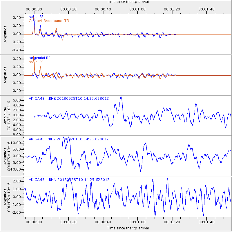
| Radial Match: |
89.82103 % |
| Radial Bump: |
355 |
| Transverse Match: |
75.058 % |
| Transverse Bump: |
400 |
| SOD ConfigId: |
13570011 |
| Insert Time: |
2019-05-01 08:47:32.073 +0000 |
| GWidth: |
2.5 |
| Max Bumps: |
400 |
| Tol: |
0.001 |
|
Signal To Noise
| Channel | StoN | STA | LTA |
| AK:GAMB: :BHZ:20180928T10:14:25.62801Z | 3.5040765 | 2.1670003E-6 | 6.1842263E-7 |
| AK:GAMB: :BHN:20180928T10:14:25.62801Z | 1.0404079 | 4.5804438E-7 | 4.402546E-7 |
| AK:GAMB: :BHE:20180928T10:14:25.62801Z | 1.4640813 | 9.660328E-7 | 6.598218E-7 |
| Arrivals |
| Ps | 3.8 SECOND |
| PpPs | 13 SECOND |
| PsPs/PpSs | 17 SECOND |


