You are here: Home > Network List > AK - Alaska Regional Network Stations List
> Station UNV Unalaska Valley > Earthquake Result Viewer
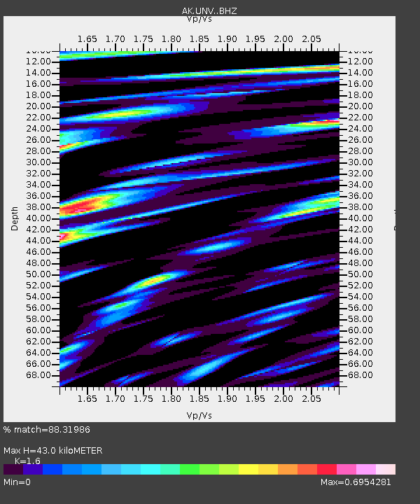
UNV Unalaska Valley - Earthquake Result Viewer
| Earthquake location: |
Minahassa Peninsula, Sulawesi |
| Earthquake latitude/longitude: |
-0.2/119.8 |
| Earthquake time(UTC): |
2018/09/28 (271) 10:02:43 GMT |
| Earthquake Depth: |
10 km |
| Earthquake Magnitude: |
7.5 Mww |
| Earthquake Catalog/Contributor: |
NEIC PDE/us |
|
| Network: |
AK Alaska Regional Network |
| Station: |
UNV Unalaska Valley |
| Lat/Lon: |
53.85 N/166.50 W |
| Elevation: |
67 m |
|
| Distance: |
80.5 deg |
| Az: |
35.199 deg |
| Baz: |
256.607 deg |
| Ray Param: |
0.04820167 |
| Estimated Moho Depth: |
43.0 km |
| Estimated Crust Vp/Vs: |
1.60 |
| Assumed Crust Vp: |
3.943 km/s |
| Estimated Crust Vs: |
2.465 km/s |
| Estimated Crust Poisson's Ratio: |
0.18 |
|
| Radial Match: |
88.31986 % |
| Radial Bump: |
395 |
| Transverse Match: |
77.829956 % |
| Transverse Bump: |
400 |
| SOD ConfigId: |
13570011 |
| Insert Time: |
2019-05-01 08:48:08.043 +0000 |
| GWidth: |
2.5 |
| Max Bumps: |
400 |
| Tol: |
0.001 |
|

Signal To Noise
| Channel | StoN | STA | LTA |
| AK:UNV: :BHZ:20180928T10:14:24.427998Z | 4.486873 | 3.6298525E-6 | 8.0899383E-7 |
| AK:UNV: :BHN:20180928T10:14:24.427998Z | 1.1980455 | 9.599466E-7 | 8.012606E-7 |
| AK:UNV: :BHE:20180928T10:14:24.427998Z | 3.280687 | 1.523636E-6 | 4.6442588E-7 |
| Arrivals |
| Ps | 6.6 SECOND |
| PpPs | 28 SECOND |
| PsPs/PpSs | 35 SECOND |


