You are here: Home > Network List > AK - Alaska Regional Network Stations List
> Station WAT6 Susitna Watana 6, AK, USA > Earthquake Result Viewer
WAT6 Susitna Watana 6, AK, USA - Earthquake Result Viewer
| Earthquake location: |
Minahassa Peninsula, Sulawesi |
| Earthquake latitude/longitude: |
-0.2/119.8 |
| Earthquake time(UTC): |
2018/09/28 (271) 10:02:43 GMT |
| Earthquake Depth: |
10 km |
| Earthquake Magnitude: |
7.5 Mww |
| Earthquake Catalog/Contributor: |
NEIC PDE/us |
|
| Network: |
AK Alaska Regional Network |
| Station: |
WAT6 Susitna Watana 6, AK, USA |
| Lat/Lon: |
62.58 N/147.74 W |
| Elevation: |
1681 m |
|
| Distance: |
91.3 deg |
| Az: |
27.558 deg |
| Baz: |
272.063 deg |
| Ray Param: |
0.041613545 |
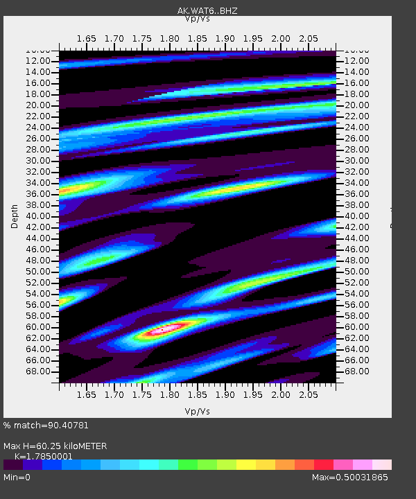
| Estimated Moho Depth: |
60.25 km |
| Estimated Crust Vp/Vs: |
1.79 |
| Assumed Crust Vp: |
6.566 km/s |
| Estimated Crust Vs: |
3.679 km/s |
| Estimated Crust Poisson's Ratio: |
0.27 |
|
| Radial Match: |
90.40781 % |
| Radial Bump: |
371 |
| Transverse Match: |
63.69434 % |
| Transverse Bump: |
400 |
| SOD ConfigId: |
13570011 |
| Insert Time: |
2019-05-01 08:48:11.417 +0000 |
| GWidth: |
2.5 |
| Max Bumps: |
400 |
| Tol: |
0.001 |
|

Signal To Noise
| Channel | StoN | STA | LTA |
| AK:WAT6: :BHZ:20180928T10:15:17.407979Z | 4.9055195 | 1.3532649E-6 | 2.7586577E-7 |
| AK:WAT6: :BHN:20180928T10:15:17.407979Z | 1.147597 | 3.9756395E-7 | 3.4643168E-7 |
| AK:WAT6: :BHE:20180928T10:15:17.407979Z | 2.2360983 | 6.098553E-7 | 2.727319E-7 |
| Arrivals |
| Ps | 7.4 SECOND |
| PpPs | 25 SECOND |
| PsPs/PpSs | 32 SECOND |


