You are here: Home > Network List > AT - Alaska Tsunami Warning Seismic System Stations List
> Station SVW2 Sparrevohn, Alaska > Earthquake Result Viewer
SVW2 Sparrevohn, Alaska - Earthquake Result Viewer
| Earthquake location: |
Minahassa Peninsula, Sulawesi |
| Earthquake latitude/longitude: |
-0.2/119.8 |
| Earthquake time(UTC): |
2018/09/28 (271) 10:02:43 GMT |
| Earthquake Depth: |
10 km |
| Earthquake Magnitude: |
7.5 Mww |
| Earthquake Catalog/Contributor: |
NEIC PDE/us |
|
| Network: |
AT Alaska Tsunami Warning Seismic System |
| Station: |
SVW2 Sparrevohn, Alaska |
| Lat/Lon: |
61.11 N/155.62 W |
| Elevation: |
499 m |
|
| Distance: |
87.5 deg |
| Az: |
28.94 deg |
| Baz: |
265.136 deg |
| Ray Param: |
0.043278243 |
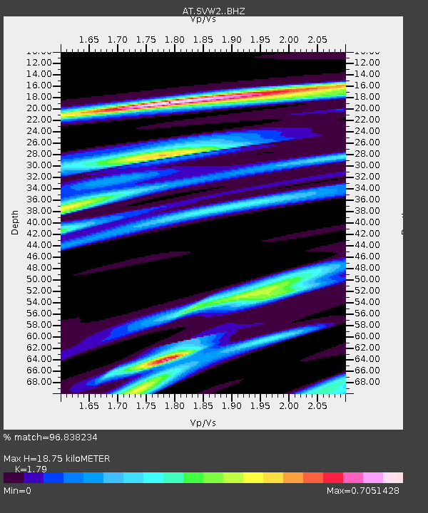
| Estimated Moho Depth: |
18.75 km |
| Estimated Crust Vp/Vs: |
1.79 |
| Assumed Crust Vp: |
6.566 km/s |
| Estimated Crust Vs: |
3.668 km/s |
| Estimated Crust Poisson's Ratio: |
0.27 |
|
| Radial Match: |
96.838234 % |
| Radial Bump: |
229 |
| Transverse Match: |
97.31382 % |
| Transverse Bump: |
152 |
| SOD ConfigId: |
13570011 |
| Insert Time: |
2019-05-01 08:48:17.354 +0000 |
| GWidth: |
2.5 |
| Max Bumps: |
400 |
| Tol: |
0.001 |
|

Signal To Noise
| Channel | StoN | STA | LTA |
| AT:SVW2: :BHZ:20180928T10:14:59.760029Z | 3.369049 | 9.655637E-7 | 2.8659827E-7 |
| AT:SVW2: :BHN:20180928T10:14:59.760029Z | 2.293549 | 3.8010646E-7 | 1.657285E-7 |
| AT:SVW2: :BHE:20180928T10:14:59.760029Z | 2.8799586 | 7.479345E-7 | 2.5970323E-7 |
| Arrivals |
| Ps | 2.3 SECOND |
| PpPs | 7.8 SECOND |
| PsPs/PpSs | 10 SECOND |


