You are here: Home > Network List > AU - Australian Seismological Centre Stations List
> Station MAW Mawson, Antarctica > Earthquake Result Viewer
MAW Mawson, Antarctica - Earthquake Result Viewer
| Earthquake location: |
Minahassa Peninsula, Sulawesi |
| Earthquake latitude/longitude: |
-0.2/119.8 |
| Earthquake time(UTC): |
2018/09/28 (271) 10:02:43 GMT |
| Earthquake Depth: |
10 km |
| Earthquake Magnitude: |
7.5 Mww |
| Earthquake Catalog/Contributor: |
NEIC PDE/us |
|
| Network: |
AU Australian Seismological Centre |
| Station: |
MAW Mawson, Antarctica |
| Lat/Lon: |
67.60 S/62.87 E |
| Elevation: |
12 m |
|
| Distance: |
77.8 deg |
| Az: |
199.191 deg |
| Baz: |
59.073 deg |
| Ray Param: |
0.050092217 |
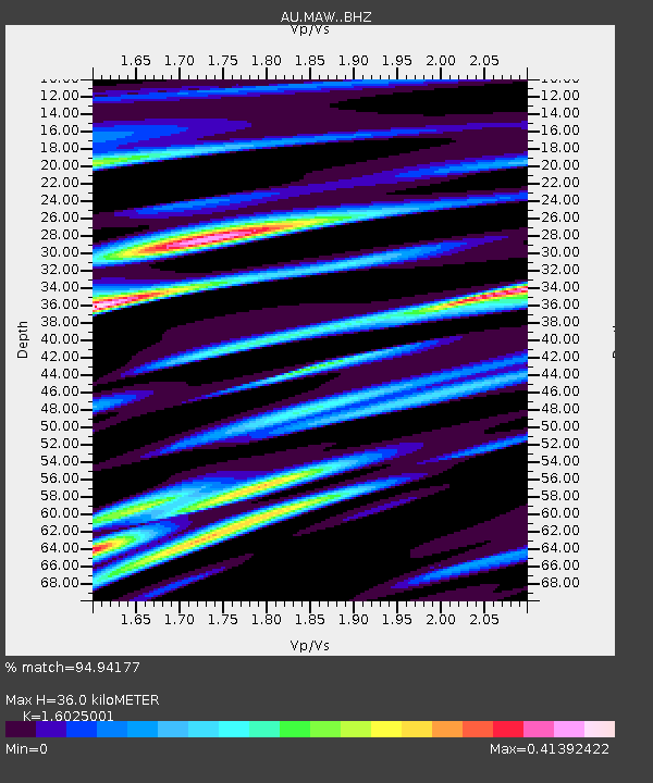
| Estimated Moho Depth: |
36.0 km |
| Estimated Crust Vp/Vs: |
1.60 |
| Assumed Crust Vp: |
6.508 km/s |
| Estimated Crust Vs: |
4.061 km/s |
| Estimated Crust Poisson's Ratio: |
0.18 |
|
| Radial Match: |
94.94177 % |
| Radial Bump: |
400 |
| Transverse Match: |
87.770935 % |
| Transverse Bump: |
400 |
| SOD ConfigId: |
13570011 |
| Insert Time: |
2019-05-01 08:48:24.895 +0000 |
| GWidth: |
2.5 |
| Max Bumps: |
400 |
| Tol: |
0.001 |
|

Signal To Noise
| Channel | StoN | STA | LTA |
| AU:MAW: :BHZ:20180928T10:14:09.336995Z | 35.08585 | 8.251986E-7 | 2.3519414E-8 |
| AU:MAW: :BHN:20180928T10:14:09.336995Z | 10.132334 | 1.8280583E-7 | 1.804183E-8 |
| AU:MAW: :BHE:20180928T10:14:09.336995Z | 17.002201 | 2.8896136E-7 | 1.6995525E-8 |
| Arrivals |
| Ps | 3.4 SECOND |
| PpPs | 14 SECOND |
| PsPs/PpSs | 17 SECOND |


