You are here: Home > Network List > AU - Australian Seismological Centre Stations List
> Station NWAO Narrogin, Western Australia > Earthquake Result Viewer
NWAO Narrogin, Western Australia - Earthquake Result Viewer
| Earthquake location: |
Minahassa Peninsula, Sulawesi |
| Earthquake latitude/longitude: |
-0.2/119.8 |
| Earthquake time(UTC): |
2018/09/28 (271) 10:02:43 GMT |
| Earthquake Depth: |
10 km |
| Earthquake Magnitude: |
7.5 Mww |
| Earthquake Catalog/Contributor: |
NEIC PDE/us |
|
| Network: |
AU Australian Seismological Centre |
| Station: |
NWAO Narrogin, Western Australia |
| Lat/Lon: |
32.93 S/117.24 E |
| Elevation: |
265 m |
|
| Distance: |
32.7 deg |
| Az: |
184.055 deg |
| Baz: |
4.823 deg |
| Ray Param: |
0.07855412 |
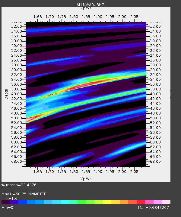
| Estimated Moho Depth: |
50.75 km |
| Estimated Crust Vp/Vs: |
1.60 |
| Assumed Crust Vp: |
6.419 km/s |
| Estimated Crust Vs: |
4.012 km/s |
| Estimated Crust Poisson's Ratio: |
0.18 |
|
| Radial Match: |
93.4376 % |
| Radial Bump: |
203 |
| Transverse Match: |
94.20703 % |
| Transverse Bump: |
203 |
| SOD ConfigId: |
13570011 |
| Insert Time: |
2019-05-01 08:48:25.667 +0000 |
| GWidth: |
2.5 |
| Max Bumps: |
400 |
| Tol: |
0.001 |
|

Signal To Noise
| Channel | StoN | STA | LTA |
| AU:NWAO: :BHZ:20180928T10:08:44.950001Z | 14.010228 | 3.2139083E-5 | 2.2939728E-6 |
| AU:NWAO: :BH1:20180928T10:08:44.950001Z | 9.8825865 | 2.378892E-5 | 2.4071553E-6 |
| AU:NWAO: :BH2:20180928T10:08:44.950001Z | 2.3305771 | 2.152455E-6 | 9.235717E-7 |
| Arrivals |
| Ps | 5.2 SECOND |
| PpPs | 19 SECOND |
| PsPs/PpSs | 24 SECOND |


