You are here: Home > Network List > CB - China National Seismic Network Stations List
> Station HEH Heihe,Heilongjiang Province > Earthquake Result Viewer
HEH Heihe,Heilongjiang Province - Earthquake Result Viewer

| Earthquake location: |
Minahassa Peninsula, Sulawesi |
| Earthquake latitude/longitude: |
-0.2/119.8 |
| Earthquake time(UTC): |
2018/09/28 (271) 10:02:43 GMT |
| Earthquake Depth: |
10 km |
| Earthquake Magnitude: |
7.5 Mww |
| Earthquake Catalog/Contributor: |
NEIC PDE/us |
|
| Network: |
CB China National Seismic Network |
| Station: |
HEH Heihe,Heilongjiang Province |
| Lat/Lon: |
50.25 N/127.41 E |
| Elevation: |
165 m |
|
| Distance: |
50.7 deg |
| Az: |
6.278 deg |
| Baz: |
189.808 deg |
| Ray Param: |
0.0679098 |
| Estimated Moho Depth: |
31.0 km |
| Estimated Crust Vp/Vs: |
1.77 |
| Assumed Crust Vp: |
6.419 km/s |
| Estimated Crust Vs: |
3.622 km/s |
| Estimated Crust Poisson's Ratio: |
0.27 |
|
| Radial Match: |
97.10476 % |
| Radial Bump: |
269 |
| Transverse Match: |
88.522705 % |
| Transverse Bump: |
400 |
| SOD ConfigId: |
13570011 |
| Insert Time: |
2019-05-01 08:49:10.563 +0000 |
| GWidth: |
2.5 |
| Max Bumps: |
400 |
| Tol: |
0.001 |
|
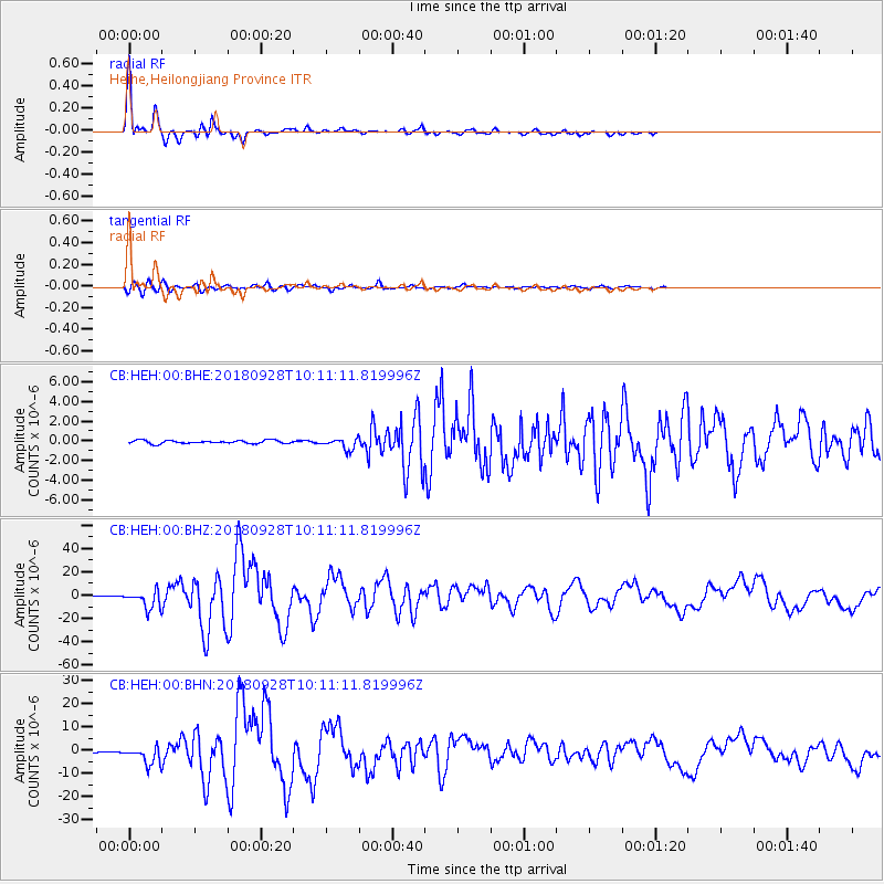
Signal To Noise
| Channel | StoN | STA | LTA |
| CB:HEH:00:BHZ:20180928T10:11:11.819996Z | 27.683668 | 7.547461E-6 | 2.7263226E-7 |
| CB:HEH:00:BHN:20180928T10:11:11.819996Z | 42.487423 | 3.6268284E-6 | 8.53624E-8 |
| CB:HEH:00:BHE:20180928T10:11:11.819996Z | 3.4767425 | 5.780985E-7 | 1.6627591E-7 |
| Arrivals |
| Ps | 4.0 SECOND |
| PpPs | 13 SECOND |
| PsPs/PpSs | 17 SECOND |


