You are here: Home > Network List > CB - China National Seismic Network Stations List
> Station LZH Lanzhou,Gansu Province > Earthquake Result Viewer
LZH Lanzhou,Gansu Province - Earthquake Result Viewer
| Earthquake location: |
Minahassa Peninsula, Sulawesi |
| Earthquake latitude/longitude: |
-0.2/119.8 |
| Earthquake time(UTC): |
2018/09/28 (271) 10:02:43 GMT |
| Earthquake Depth: |
10 km |
| Earthquake Magnitude: |
7.5 Mww |
| Earthquake Catalog/Contributor: |
NEIC PDE/us |
|
| Network: |
CB China National Seismic Network |
| Station: |
LZH Lanzhou,Gansu Province |
| Lat/Lon: |
36.09 N/103.84 E |
| Elevation: |
1560 m |
|
| Distance: |
39.0 deg |
| Az: |
339.24 deg |
| Baz: |
154.049 deg |
| Ray Param: |
0.075220376 |
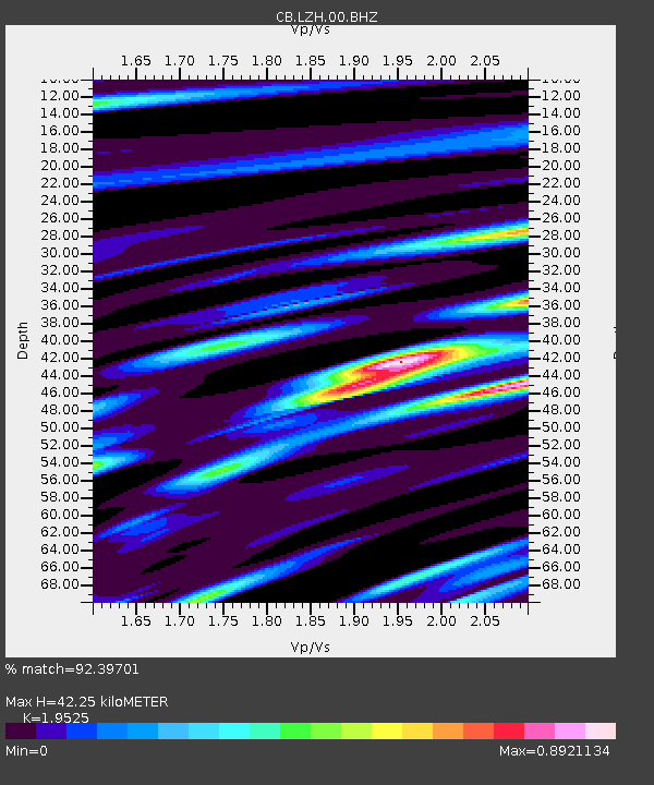
| Estimated Moho Depth: |
42.25 km |
| Estimated Crust Vp/Vs: |
1.95 |
| Assumed Crust Vp: |
6.306 km/s |
| Estimated Crust Vs: |
3.23 km/s |
| Estimated Crust Poisson's Ratio: |
0.32 |
|
| Radial Match: |
92.39701 % |
| Radial Bump: |
400 |
| Transverse Match: |
77.47861 % |
| Transverse Bump: |
400 |
| SOD ConfigId: |
13570011 |
| Insert Time: |
2019-05-01 08:49:17.099 +0000 |
| GWidth: |
2.5 |
| Max Bumps: |
400 |
| Tol: |
0.001 |
|

Signal To Noise
| Channel | StoN | STA | LTA |
| CB:LZH:00:BHZ:20180928T10:09:39.360005Z | 19.729757 | 5.14992E-6 | 2.61023E-7 |
| CB:LZH:00:BHN:20180928T10:09:39.360005Z | 6.687269 | 2.3133452E-6 | 3.459327E-7 |
| CB:LZH:00:BHE:20180928T10:09:39.360005Z | 3.3592932 | 1.1013466E-6 | 3.2785067E-7 |
| Arrivals |
| Ps | 6.8 SECOND |
| PpPs | 19 SECOND |
| PsPs/PpSs | 25 SECOND |


