You are here: Home > Network List > KO - Kandilli Observatory Digital Broadband Seismic Network Stations List
> Station ELL Elmali-Antalya-Turkey > Earthquake Result Viewer
ELL Elmali-Antalya-Turkey - Earthquake Result Viewer
| Earthquake location: |
Minahassa Peninsula, Sulawesi |
| Earthquake latitude/longitude: |
-0.2/119.8 |
| Earthquake time(UTC): |
2018/09/28 (271) 10:02:43 GMT |
| Earthquake Depth: |
10 km |
| Earthquake Magnitude: |
7.5 Mww |
| Earthquake Catalog/Contributor: |
NEIC PDE/us |
|
| Network: |
KO Kandilli Observatory Digital Broadband Seismic Network |
| Station: |
ELL Elmali-Antalya-Turkey |
| Lat/Lon: |
36.75 N/29.91 E |
| Elevation: |
1230 m |
|
| Distance: |
90.1 deg |
| Az: |
306.564 deg |
| Baz: |
90.183 deg |
| Ray Param: |
0.041701015 |
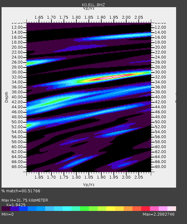
| Estimated Moho Depth: |
31.75 km |
| Estimated Crust Vp/Vs: |
1.94 |
| Assumed Crust Vp: |
6.12 km/s |
| Estimated Crust Vs: |
3.151 km/s |
| Estimated Crust Poisson's Ratio: |
0.32 |
|
| Radial Match: |
80.51766 % |
| Radial Bump: |
400 |
| Transverse Match: |
63.396812 % |
| Transverse Bump: |
400 |
| SOD ConfigId: |
13570011 |
| Insert Time: |
2019-05-01 08:50:11.004 +0000 |
| GWidth: |
2.5 |
| Max Bumps: |
400 |
| Tol: |
0.001 |
|

Signal To Noise
| Channel | StoN | STA | LTA |
| KO:ELL: :BHZ:20180928T10:15:11.74001Z | 9.297004 | 4.543728E-6 | 4.887304E-7 |
| KO:ELL: :BHN:20180928T10:15:11.74001Z | 1.0078542 | 8.0638006E-7 | 8.0009596E-7 |
| KO:ELL: :BHE:20180928T10:15:11.74001Z | 0.94065726 | 1.1942928E-6 | 1.2696366E-6 |
| Arrivals |
| Ps | 5.0 SECOND |
| PpPs | 15 SECOND |
| PsPs/PpSs | 20 SECOND |


