You are here: Home > Network List > KO - Kandilli Observatory Digital Broadband Seismic Network Stations List
> Station GAZ Gaziantep-Turkey > Earthquake Result Viewer
GAZ Gaziantep-Turkey - Earthquake Result Viewer
| Earthquake location: |
Minahassa Peninsula, Sulawesi |
| Earthquake latitude/longitude: |
-0.2/119.8 |
| Earthquake time(UTC): |
2018/09/28 (271) 10:02:43 GMT |
| Earthquake Depth: |
10 km |
| Earthquake Magnitude: |
7.5 Mww |
| Earthquake Catalog/Contributor: |
NEIC PDE/us |
|
| Network: |
KO Kandilli Observatory Digital Broadband Seismic Network |
| Station: |
GAZ Gaziantep-Turkey |
| Lat/Lon: |
37.17 N/37.21 E |
| Elevation: |
992 m |
|
| Distance: |
84.2 deg |
| Az: |
307.23 deg |
| Baz: |
94.591 deg |
| Ray Param: |
0.045632772 |
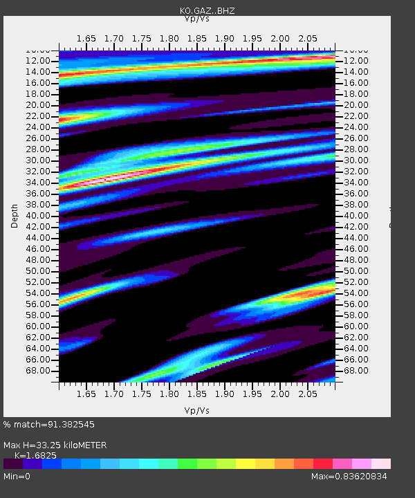
| Estimated Moho Depth: |
33.25 km |
| Estimated Crust Vp/Vs: |
1.68 |
| Assumed Crust Vp: |
6.247 km/s |
| Estimated Crust Vs: |
3.713 km/s |
| Estimated Crust Poisson's Ratio: |
0.23 |
|
| Radial Match: |
91.382545 % |
| Radial Bump: |
391 |
| Transverse Match: |
82.30902 % |
| Transverse Bump: |
400 |
| SOD ConfigId: |
13570011 |
| Insert Time: |
2019-05-01 08:50:11.423 +0000 |
| GWidth: |
2.5 |
| Max Bumps: |
400 |
| Tol: |
0.001 |
|

Signal To Noise
| Channel | StoN | STA | LTA |
| KO:GAZ: :BHZ:20180928T10:14:43.579976Z | 26.454676 | 2.7810931E-6 | 1.05126716E-7 |
| KO:GAZ: :BHN:20180928T10:14:43.579976Z | 1.2154336 | 8.7208875E-8 | 7.1751245E-8 |
| KO:GAZ: :BHE:20180928T10:14:43.579976Z | 6.7848854 | 7.981905E-7 | 1.1764245E-7 |
| Arrivals |
| Ps | 3.7 SECOND |
| PpPs | 14 SECOND |
| PsPs/PpSs | 18 SECOND |


