You are here: Home > Network List > KO - Kandilli Observatory Digital Broadband Seismic Network Stations List
> Station KARS Kars-Turkey > Earthquake Result Viewer
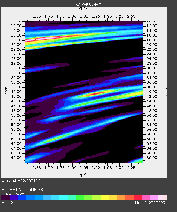
KARS Kars-Turkey - Earthquake Result Viewer
| Earthquake location: |
Minahassa Peninsula, Sulawesi |
| Earthquake latitude/longitude: |
-0.2/119.8 |
| Earthquake time(UTC): |
2018/09/28 (271) 10:02:43 GMT |
| Earthquake Depth: |
10 km |
| Earthquake Magnitude: |
7.5 Mww |
| Earthquake Catalog/Contributor: |
NEIC PDE/us |
|
| Network: |
KO Kandilli Observatory Digital Broadband Seismic Network |
| Station: |
KARS Kars-Turkey |
| Lat/Lon: |
40.62 N/43.09 E |
| Elevation: |
1747 m |
|
| Distance: |
80.1 deg |
| Az: |
311.214 deg |
| Baz: |
98.819 deg |
| Ray Param: |
0.048531163 |
| Estimated Moho Depth: |
17.5 km |
| Estimated Crust Vp/Vs: |
1.64 |
| Assumed Crust Vp: |
6.419 km/s |
| Estimated Crust Vs: |
3.908 km/s |
| Estimated Crust Poisson's Ratio: |
0.21 |
|
| Radial Match: |
90.667114 % |
| Radial Bump: |
347 |
| Transverse Match: |
83.72853 % |
| Transverse Bump: |
400 |
| SOD ConfigId: |
13570011 |
| Insert Time: |
2019-05-01 08:50:11.556 +0000 |
| GWidth: |
2.5 |
| Max Bumps: |
400 |
| Tol: |
0.001 |
|

Signal To Noise
| Channel | StoN | STA | LTA |
| KO:KARS: :HHZ:20180928T10:14:21.849995Z | 18.114344 | 8.968783E-6 | 4.951205E-7 |
| KO:KARS: :HHN:20180928T10:14:21.849995Z | 0.79543287 | 4.93466E-7 | 6.2037424E-7 |
| KO:KARS: :HHE:20180928T10:14:21.849995Z | 2.6931195 | 1.4371932E-6 | 5.3365375E-7 |
| Arrivals |
| Ps | 1.8 SECOND |
| PpPs | 7.0 SECOND |
| PsPs/PpSs | 8.8 SECOND |


