You are here: Home > Network List > TA - USArray Transportable Network (new EarthScope stations) Stations List
> Station U15A North Rim, AZ, USA > Earthquake Result Viewer
U15A North Rim, AZ, USA - Earthquake Result Viewer
| Earthquake location: |
Kuril Islands |
| Earthquake latitude/longitude: |
51.0/157.6 |
| Earthquake time(UTC): |
2008/07/24 (206) 01:43:16 GMT |
| Earthquake Depth: |
27 km |
| Earthquake Magnitude: |
6.0 MB, 6.0 MS, 6.2 MW, 6.2 MW |
| Earthquake Catalog/Contributor: |
WHDF/NEIC |
|
| Network: |
TA USArray Transportable Network (new EarthScope stations) |
| Station: |
U15A North Rim, AZ, USA |
| Lat/Lon: |
36.43 N/112.29 W |
| Elevation: |
2489 m |
|
| Distance: |
62.8 deg |
| Az: |
65.051 deg |
| Baz: |
314.695 deg |
| Ray Param: |
0.059943713 |
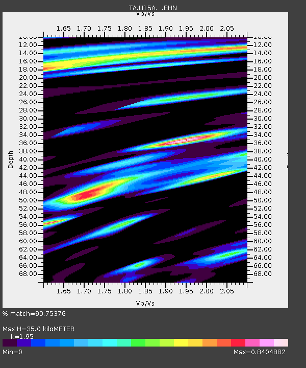
| Estimated Moho Depth: |
35.0 km |
| Estimated Crust Vp/Vs: |
1.95 |
| Assumed Crust Vp: |
6.194 km/s |
| Estimated Crust Vs: |
3.177 km/s |
| Estimated Crust Poisson's Ratio: |
0.32 |
|
| Radial Match: |
90.75376 % |
| Radial Bump: |
400 |
| Transverse Match: |
79.822685 % |
| Transverse Bump: |
400 |
| SOD ConfigId: |
2504 |
| Insert Time: |
2010-03-06 16:18:45.668 +0000 |
| GWidth: |
2.5 |
| Max Bumps: |
400 |
| Tol: |
0.001 |
|

Signal To Noise
| Channel | StoN | STA | LTA |
| TA:U15A: :BHN:20080724T01:53:08.324021Z | 15.746826 | 1.1744334E-6 | 7.458223E-8 |
| TA:U15A: :BHE:20080724T01:53:08.324021Z | 3.4939632 | 3.24596E-7 | 9.290195E-8 |
| TA:U15A: :BHZ:20080724T01:53:08.324021Z | 5.166482 | 4.21528E-7 | 8.158898E-8 |
| Arrivals |
| Ps | 5.6 SECOND |
| PpPs | 16 SECOND |
| PsPs/PpSs | 22 SECOND |


