You are here: Home > Network List > PL - Polish Seismological Network Stations List
> Station HSPB > Earthquake Result Viewer
HSPB - Earthquake Result Viewer
| Earthquake location: |
Minahassa Peninsula, Sulawesi |
| Earthquake latitude/longitude: |
-0.2/119.8 |
| Earthquake time(UTC): |
2018/09/28 (271) 10:02:43 GMT |
| Earthquake Depth: |
10 km |
| Earthquake Magnitude: |
7.5 Mww |
| Earthquake Catalog/Contributor: |
NEIC PDE/us |
|
| Network: |
PL Polish Seismological Network |
| Station: |
HSPB |
| Lat/Lon: |
77.00 N/15.53 E |
| Elevation: |
11 m |
|
| Distance: |
93.4 deg |
| Az: |
347.307 deg |
| Baz: |
76.089 deg |
| Ray Param: |
0.041272353 |
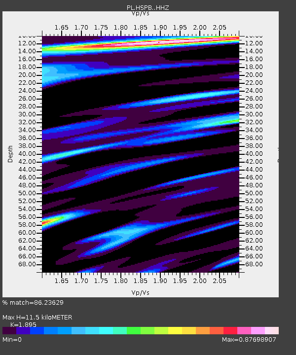
| Estimated Moho Depth: |
11.5 km |
| Estimated Crust Vp/Vs: |
1.89 |
| Assumed Crust Vp: |
6.287 km/s |
| Estimated Crust Vs: |
3.318 km/s |
| Estimated Crust Poisson's Ratio: |
0.31 |
|
| Radial Match: |
86.23629 % |
| Radial Bump: |
389 |
| Transverse Match: |
75.55585 % |
| Transverse Bump: |
400 |
| SOD ConfigId: |
13570011 |
| Insert Time: |
2019-05-01 08:50:49.178 +0000 |
| GWidth: |
2.5 |
| Max Bumps: |
400 |
| Tol: |
0.001 |
|

Signal To Noise
| Channel | StoN | STA | LTA |
| PL:HSPB: :HHZ:20180928T10:15:27.084004Z | 2.965627 | 7.871568E-7 | 2.6542676E-7 |
| PL:HSPB: :HHN:20180928T10:15:27.084004Z | 1.144449 | 1.7487542E-7 | 1.5280317E-7 |
| PL:HSPB: :HHE:20180928T10:15:27.084004Z | 1.6570679 | 4.4201352E-7 | 2.6674437E-7 |
| Arrivals |
| Ps | 1.7 SECOND |
| PpPs | 5.2 SECOND |
| PsPs/PpSs | 6.9 SECOND |


