You are here: Home > Network List > S - Seismographs in Schools Projects Stations List
> Station AUAYR Ayr State High School, QLD > Earthquake Result Viewer
AUAYR Ayr State High School, QLD - Earthquake Result Viewer
| Earthquake location: |
Minahassa Peninsula, Sulawesi |
| Earthquake latitude/longitude: |
-0.2/119.8 |
| Earthquake time(UTC): |
2018/09/28 (271) 10:02:43 GMT |
| Earthquake Depth: |
10 km |
| Earthquake Magnitude: |
7.5 Mww |
| Earthquake Catalog/Contributor: |
NEIC PDE/us |
|
| Network: |
S Seismographs in Schools Projects |
| Station: |
AUAYR Ayr State High School, QLD |
| Lat/Lon: |
19.58 S/147.41 E |
| Elevation: |
13 m |
|
| Distance: |
33.2 deg |
| Az: |
127.139 deg |
| Baz: |
302.28 deg |
| Ray Param: |
0.0783218 |
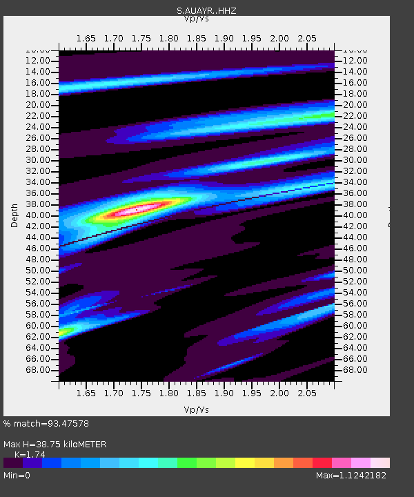
| Estimated Moho Depth: |
38.75 km |
| Estimated Crust Vp/Vs: |
1.74 |
| Assumed Crust Vp: |
6.472 km/s |
| Estimated Crust Vs: |
3.719 km/s |
| Estimated Crust Poisson's Ratio: |
0.25 |
|
| Radial Match: |
93.47578 % |
| Radial Bump: |
203 |
| Transverse Match: |
68.04107 % |
| Transverse Bump: |
400 |
| SOD ConfigId: |
13570011 |
| Insert Time: |
2019-05-01 08:50:56.002 +0000 |
| GWidth: |
2.5 |
| Max Bumps: |
400 |
| Tol: |
0.001 |
|

Signal To Noise
| Channel | StoN | STA | LTA |
| S:AUAYR: :HHZ:20180928T10:08:49.509999Z | 4.270007 | 2.0984319E-6 | 4.9143523E-7 |
| S:AUAYR: :HHN:20180928T10:08:49.509999Z | 2.007823 | 1.0331922E-6 | 5.1458335E-7 |
| S:AUAYR: :HHE:20180928T10:08:49.509999Z | 2.5424376 | 1.7950299E-6 | 7.0602715E-7 |
| Arrivals |
| Ps | 4.8 SECOND |
| PpPs | 15 SECOND |
| PsPs/PpSs | 20 SECOND |


