You are here: Home > Network List > S - Seismographs in Schools Projects Stations List
> Station AUMTS Mt Stromlo, ANU > Earthquake Result Viewer
AUMTS Mt Stromlo, ANU - Earthquake Result Viewer
| Earthquake location: |
Minahassa Peninsula, Sulawesi |
| Earthquake latitude/longitude: |
-0.2/119.8 |
| Earthquake time(UTC): |
2018/09/28 (271) 10:02:43 GMT |
| Earthquake Depth: |
10 km |
| Earthquake Magnitude: |
7.5 Mww |
| Earthquake Catalog/Contributor: |
NEIC PDE/us |
|
| Network: |
S Seismographs in Schools Projects |
| Station: |
AUMTS Mt Stromlo, ANU |
| Lat/Lon: |
35.32 S/149.00 E |
| Elevation: |
667 m |
|
| Distance: |
44.3 deg |
| Az: |
145.204 deg |
| Baz: |
315.748 deg |
| Ray Param: |
0.07201349 |
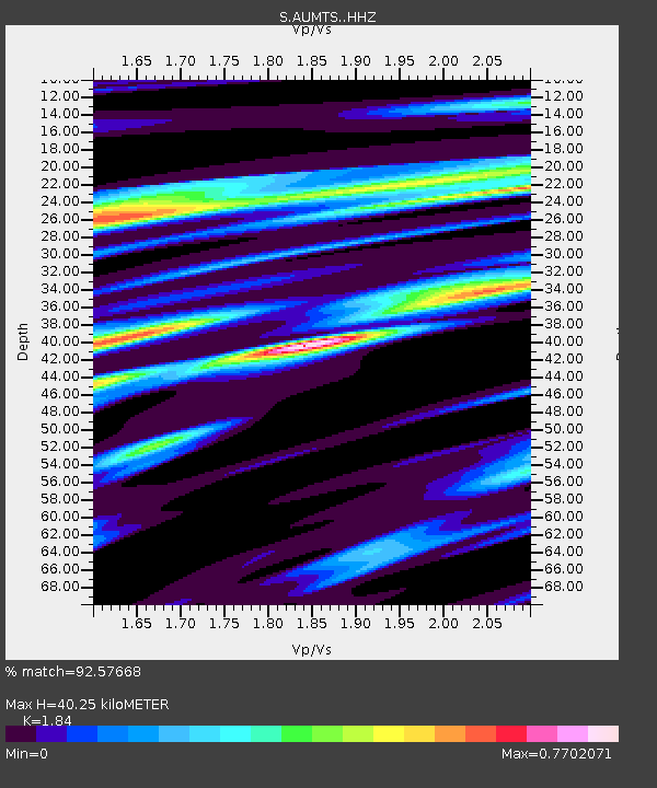
| Estimated Moho Depth: |
40.25 km |
| Estimated Crust Vp/Vs: |
1.84 |
| Assumed Crust Vp: |
6.633 km/s |
| Estimated Crust Vs: |
3.605 km/s |
| Estimated Crust Poisson's Ratio: |
0.29 |
|
| Radial Match: |
92.57668 % |
| Radial Bump: |
336 |
| Transverse Match: |
89.13921 % |
| Transverse Bump: |
400 |
| SOD ConfigId: |
13570011 |
| Insert Time: |
2019-05-01 08:51:02.830 +0000 |
| GWidth: |
2.5 |
| Max Bumps: |
400 |
| Tol: |
0.001 |
|

Signal To Noise
| Channel | StoN | STA | LTA |
| S:AUMTS: :HHZ:20180928T10:10:22.300007Z | 4.964464 | 2.546692E-6 | 5.1298423E-7 |
| S:AUMTS: :HHN:20180928T10:10:22.300007Z | 3.0319958 | 1.3018947E-6 | 4.2938538E-7 |
| S:AUMTS: :HHE:20180928T10:10:22.300007Z | 1.7926916 | 8.3771454E-7 | 4.672943E-7 |
| Arrivals |
| Ps | 5.5 SECOND |
| PpPs | 16 SECOND |
| PsPs/PpSs | 22 SECOND |


