You are here: Home > Network List > US - United States National Seismic Network Stations List
> Station CBKS Cedar Bluff, Kansas, USA > Earthquake Result Viewer
CBKS Cedar Bluff, Kansas, USA - Earthquake Result Viewer

| Earthquake location: |
Near Coast Of Northern Chile |
| Earthquake latitude/longitude: |
-26.1/-70.6 |
| Earthquake time(UTC): |
2016/07/25 (207) 17:26:49 GMT |
| Earthquake Depth: |
68 km |
| Earthquake Magnitude: |
6.2 MB |
| Earthquake Catalog/Contributor: |
NEIC PDE/NEIC COMCAT |
|
| Network: |
US United States National Seismic Network |
| Station: |
CBKS Cedar Bluff, Kansas, USA |
| Lat/Lon: |
38.81 N/99.74 W |
| Elevation: |
677 m |
|
| Distance: |
70.1 deg |
| Az: |
336.172 deg |
| Baz: |
152.292 deg |
| Ray Param: |
0.055062097 |
| Estimated Moho Depth: |
18.75 km |
| Estimated Crust Vp/Vs: |
2.04 |
| Assumed Crust Vp: |
6.483 km/s |
| Estimated Crust Vs: |
3.182 km/s |
| Estimated Crust Poisson's Ratio: |
0.34 |
|
| Radial Match: |
96.96059 % |
| Radial Bump: |
302 |
| Transverse Match: |
84.859886 % |
| Transverse Bump: |
400 |
| SOD ConfigId: |
1634031 |
| Insert Time: |
2016-08-08 17:31:04.323 +0000 |
| GWidth: |
2.5 |
| Max Bumps: |
400 |
| Tol: |
0.001 |
|
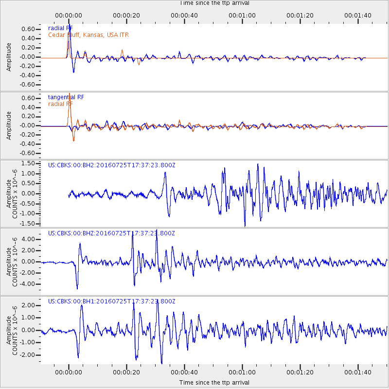
Signal To Noise
| Channel | StoN | STA | LTA |
| US:CBKS:00:BHZ:20160725T17:37:23.800Z | 21.700201 | 1.7560889E-6 | 8.0925E-8 |
| US:CBKS:00:BH1:20160725T17:37:23.800Z | 10.990227 | 9.743426E-7 | 8.865536E-8 |
| US:CBKS:00:BH2:20160725T17:37:23.800Z | 5.8770876 | 5.084938E-7 | 8.6521396E-8 |
| Arrivals |
| Ps | 3.1 SECOND |
| PpPs | 8.5 SECOND |
| PsPs/PpSs | 12 SECOND |


