You are here: Home > Network List > TA - USArray Transportable Network (new EarthScope stations) Stations List
> Station B18K Kokolik River, AK, USA > Earthquake Result Viewer
B18K Kokolik River, AK, USA - Earthquake Result Viewer
| Earthquake location: |
Minahassa Peninsula, Sulawesi |
| Earthquake latitude/longitude: |
-0.2/119.8 |
| Earthquake time(UTC): |
2018/09/28 (271) 10:02:43 GMT |
| Earthquake Depth: |
10 km |
| Earthquake Magnitude: |
7.5 Mww |
| Earthquake Catalog/Contributor: |
NEIC PDE/us |
|
| Network: |
TA USArray Transportable Network (new EarthScope stations) |
| Station: |
B18K Kokolik River, AK, USA |
| Lat/Lon: |
69.36 N/161.80 W |
| Elevation: |
222 m |
|
| Distance: |
86.1 deg |
| Az: |
20.367 deg |
| Baz: |
259.034 deg |
| Ray Param: |
0.04431763 |
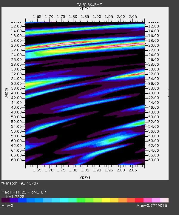
| Estimated Moho Depth: |
19.25 km |
| Estimated Crust Vp/Vs: |
1.75 |
| Assumed Crust Vp: |
5.906 km/s |
| Estimated Crust Vs: |
3.37 km/s |
| Estimated Crust Poisson's Ratio: |
0.26 |
|
| Radial Match: |
91.43707 % |
| Radial Bump: |
400 |
| Transverse Match: |
86.49087 % |
| Transverse Bump: |
400 |
| SOD ConfigId: |
13570011 |
| Insert Time: |
2019-05-01 08:51:17.559 +0000 |
| GWidth: |
2.5 |
| Max Bumps: |
400 |
| Tol: |
0.001 |
|
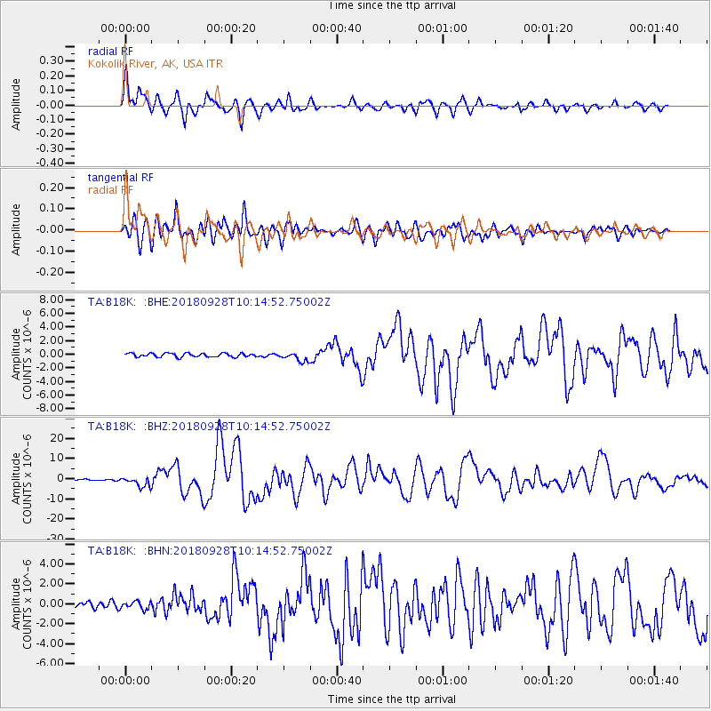
Signal To Noise
| Channel | StoN | STA | LTA |
| TA:B18K: :BHZ:20180928T10:14:52.75002Z | 7.5455594 | 2.5585512E-6 | 3.390804E-7 |
| TA:B18K: :BHN:20180928T10:14:52.75002Z | 1.4918941 | 3.835162E-7 | 2.5706666E-7 |
| TA:B18K: :BHE:20180928T10:14:52.75002Z | 2.416232 | 6.6546806E-7 | 2.7541563E-7 |
| Arrivals |
| Ps | 2.5 SECOND |
| PpPs | 8.8 SECOND |
| PsPs/PpSs | 11 SECOND |


