You are here: Home > Network List > TA - USArray Transportable Network (new EarthScope stations) Stations List
> Station C26K Camden Bay, AK, USA > Earthquake Result Viewer
C26K Camden Bay, AK, USA - Earthquake Result Viewer
| Earthquake location: |
Minahassa Peninsula, Sulawesi |
| Earthquake latitude/longitude: |
-0.2/119.8 |
| Earthquake time(UTC): |
2018/09/28 (271) 10:02:43 GMT |
| Earthquake Depth: |
10 km |
| Earthquake Magnitude: |
7.5 Mww |
| Earthquake Catalog/Contributor: |
NEIC PDE/us |
|
| Network: |
TA USArray Transportable Network (new EarthScope stations) |
| Station: |
C26K Camden Bay, AK, USA |
| Lat/Lon: |
69.92 N/144.91 W |
| Elevation: |
139 m |
|
| Distance: |
92.0 deg |
| Az: |
20.131 deg |
| Baz: |
274.865 deg |
| Ray Param: |
0.041528124 |
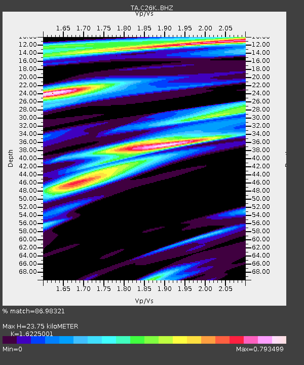
| Estimated Moho Depth: |
23.75 km |
| Estimated Crust Vp/Vs: |
1.62 |
| Assumed Crust Vp: |
6.455 km/s |
| Estimated Crust Vs: |
3.979 km/s |
| Estimated Crust Poisson's Ratio: |
0.19 |
|
| Radial Match: |
86.98321 % |
| Radial Bump: |
377 |
| Transverse Match: |
84.0682 % |
| Transverse Bump: |
400 |
| SOD ConfigId: |
13570011 |
| Insert Time: |
2019-05-01 08:51:26.968 +0000 |
| GWidth: |
2.5 |
| Max Bumps: |
400 |
| Tol: |
0.001 |
|

Signal To Noise
| Channel | StoN | STA | LTA |
| TA:C26K: :BHZ:20180928T10:15:20.649983Z | 5.367338 | 1.6139993E-6 | 3.007076E-7 |
| TA:C26K: :BHN:20180928T10:15:20.649983Z | 0.70440507 | 2.83381E-7 | 4.0229835E-7 |
| TA:C26K: :BHE:20180928T10:15:20.649983Z | 1.9176681 | 5.410919E-7 | 2.8216138E-7 |
| Arrivals |
| Ps | 2.3 SECOND |
| PpPs | 9.4 SECOND |
| PsPs/PpSs | 12 SECOND |


