You are here: Home > Network List > TA - USArray Transportable Network (new EarthScope stations) Stations List
> Station F25K Christian River, AK, USA > Earthquake Result Viewer
F25K Christian River, AK, USA - Earthquake Result Viewer
| Earthquake location: |
Minahassa Peninsula, Sulawesi |
| Earthquake latitude/longitude: |
-0.2/119.8 |
| Earthquake time(UTC): |
2018/09/28 (271) 10:02:43 GMT |
| Earthquake Depth: |
10 km |
| Earthquake Magnitude: |
7.5 Mww |
| Earthquake Catalog/Contributor: |
NEIC PDE/us |
|
| Network: |
TA USArray Transportable Network (new EarthScope stations) |
| Station: |
F25K Christian River, AK, USA |
| Lat/Lon: |
67.59 N/145.64 W |
| Elevation: |
864 m |
|
| Distance: |
91.9 deg |
| Az: |
22.482 deg |
| Baz: |
274.105 deg |
| Ray Param: |
0.041540693 |
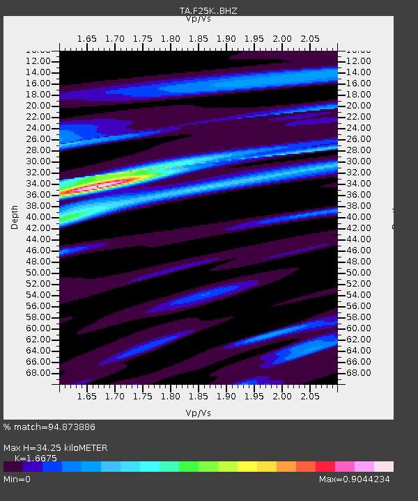
| Estimated Moho Depth: |
34.25 km |
| Estimated Crust Vp/Vs: |
1.67 |
| Assumed Crust Vp: |
6.522 km/s |
| Estimated Crust Vs: |
3.911 km/s |
| Estimated Crust Poisson's Ratio: |
0.22 |
|
| Radial Match: |
94.873886 % |
| Radial Bump: |
400 |
| Transverse Match: |
71.79385 % |
| Transverse Bump: |
400 |
| SOD ConfigId: |
13570011 |
| Insert Time: |
2019-05-01 08:51:51.255 +0000 |
| GWidth: |
2.5 |
| Max Bumps: |
400 |
| Tol: |
0.001 |
|

Signal To Noise
| Channel | StoN | STA | LTA |
| TA:F25K: :BHZ:20180928T10:15:20.25002Z | 4.6409445 | 1.0416054E-6 | 2.2443822E-7 |
| TA:F25K: :BHN:20180928T10:15:20.25002Z | 1.9901158 | 2.4324058E-7 | 1.2222434E-7 |
| TA:F25K: :BHE:20180928T10:15:20.25002Z | 1.4400594 | 3.0448157E-7 | 2.1143681E-7 |
| Arrivals |
| Ps | 3.6 SECOND |
| PpPs | 14 SECOND |
| PsPs/PpSs | 17 SECOND |


