You are here: Home > Network List > TS - TERRAscope (Southern California Seismic Network) Stations List
> Station BAR Barrett Dam, California, USA > Earthquake Result Viewer
BAR Barrett Dam, California, USA - Earthquake Result Viewer
| Earthquake location: |
Northern Colombia |
| Earthquake latitude/longitude: |
6.5/-71.2 |
| Earthquake time(UTC): |
1993/07/22 (203) 04:57:06 GMT |
| Earthquake Depth: |
19 km |
| Earthquake Magnitude: |
6.1 MB, 5.9 MS, 6.3 UNKNOWN, 6.0 MW |
| Earthquake Catalog/Contributor: |
WHDF/NEIC |
|
| Network: |
TS TERRAscope (Southern California Seismic Network) |
| Station: |
BAR Barrett Dam, California, USA |
| Lat/Lon: |
32.68 N/116.67 W |
| Elevation: |
548 m |
|
| Distance: |
49.6 deg |
| Az: |
307.877 deg |
| Baz: |
111.561 deg |
| Ray Param: |
0.06858195 |
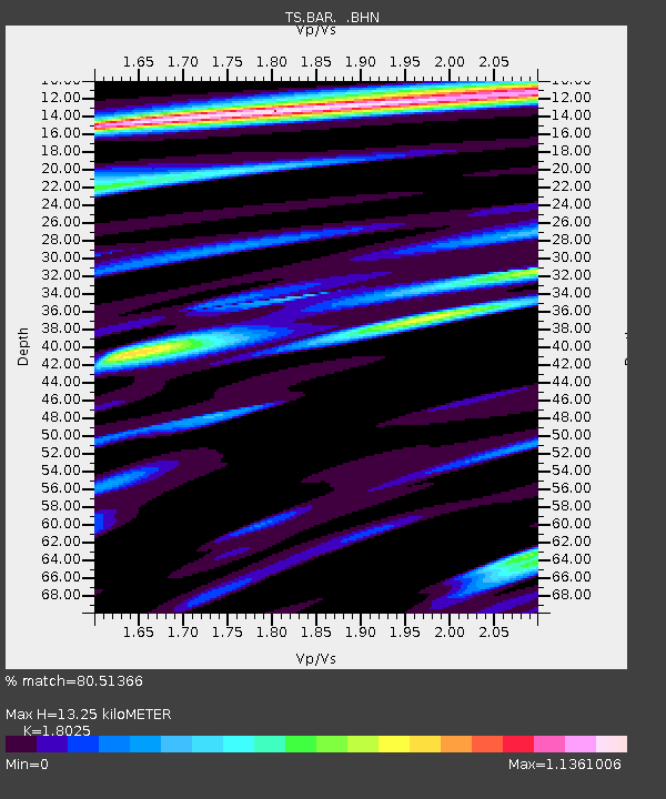
| Estimated Moho Depth: |
13.25 km |
| Estimated Crust Vp/Vs: |
1.80 |
| Assumed Crust Vp: |
6.264 km/s |
| Estimated Crust Vs: |
3.475 km/s |
| Estimated Crust Poisson's Ratio: |
0.28 |
|
| Radial Match: |
80.51366 % |
| Radial Bump: |
400 |
| Transverse Match: |
70.85918 % |
| Transverse Bump: |
400 |
| SOD ConfigId: |
16938 |
| Insert Time: |
2010-02-26 13:57:11.654 +0000 |
| GWidth: |
2.5 |
| Max Bumps: |
400 |
| Tol: |
0.001 |
|
Signal To Noise
| Channel | StoN | STA | LTA |
| TS:BAR: :BHN:19930722T05:05:25.86701Z | 1.06401 | 1.18296676E-7 | 1.1118004E-7 |
| TS:BAR: :BHE:19930722T05:05:25.86701Z | 1.690018 | 1.4161834E-7 | 8.379694E-8 |
| TS:BAR: :BHZ:19930722T05:05:25.86701Z | 1.6794091 | 2.3255262E-7 | 1.3847288E-7 |
| Arrivals |
| Ps | 1.8 SECOND |
| PpPs | 5.6 SECOND |
| PsPs/PpSs | 7.4 SECOND |


