You are here: Home > Network List > TA - USArray Transportable Network (new EarthScope stations) Stations List
> Station U15A North Rim, AZ, USA > Earthquake Result Viewer
U15A North Rim, AZ, USA - Earthquake Result Viewer
| Earthquake location: |
Central Mid-Atlantic Ridge |
| Earthquake latitude/longitude: |
8.1/-38.7 |
| Earthquake time(UTC): |
2008/09/10 (254) 13:08:14 GMT |
| Earthquake Depth: |
10 km |
| Earthquake Magnitude: |
6.3 MB, 6.5 MS, 6.6 MW, 6.6 MW |
| Earthquake Catalog/Contributor: |
WHDF/NEIC |
|
| Network: |
TA USArray Transportable Network (new EarthScope stations) |
| Station: |
U15A North Rim, AZ, USA |
| Lat/Lon: |
36.43 N/112.29 W |
| Elevation: |
2489 m |
|
| Distance: |
72.0 deg |
| Az: |
305.585 deg |
| Baz: |
93.18 deg |
| Ray Param: |
0.053931955 |
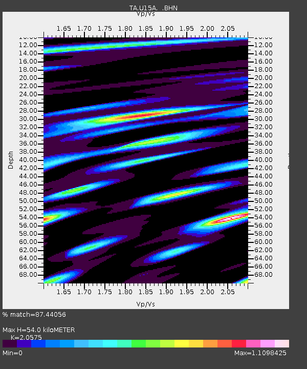
| Estimated Moho Depth: |
54.0 km |
| Estimated Crust Vp/Vs: |
2.06 |
| Assumed Crust Vp: |
6.194 km/s |
| Estimated Crust Vs: |
3.011 km/s |
| Estimated Crust Poisson's Ratio: |
0.35 |
|
| Radial Match: |
87.44056 % |
| Radial Bump: |
384 |
| Transverse Match: |
83.71727 % |
| Transverse Bump: |
400 |
| SOD ConfigId: |
2560 |
| Insert Time: |
2010-03-06 16:18:56.711 +0000 |
| GWidth: |
2.5 |
| Max Bumps: |
400 |
| Tol: |
0.001 |
|

Signal To Noise
| Channel | StoN | STA | LTA |
| TA:U15A: :BHN:20080910T13:19:07.649014Z | 2.141245 | 2.8472257E-7 | 1.3297058E-7 |
| TA:U15A: :BHE:20080910T13:19:07.649014Z | 0.5697917 | 7.045318E-8 | 1.2364728E-7 |
| TA:U15A: :BHZ:20080910T13:19:07.649014Z | 0.97782254 | 1.6700251E-7 | 1.7079022E-7 |
| Arrivals |
| Ps | 9.5 SECOND |
| PpPs | 26 SECOND |
| PsPs/PpSs | 35 SECOND |


