You are here: Home > Network List > TA - USArray Transportable Network (new EarthScope stations) Stations List
> Station G31M Satah River, YT, CAN > Earthquake Result Viewer
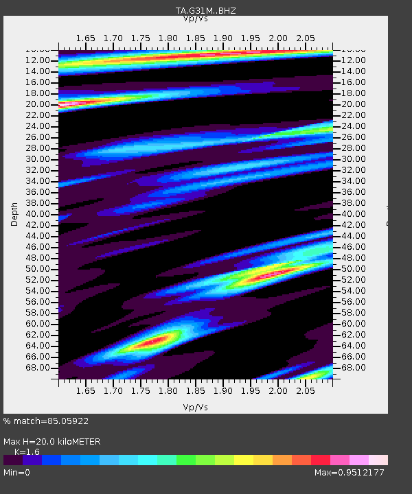
G31M Satah River, YT, CAN - Earthquake Result Viewer
| Earthquake location: |
Minahassa Peninsula, Sulawesi |
| Earthquake latitude/longitude: |
-0.2/119.8 |
| Earthquake time(UTC): |
2018/09/28 (271) 10:02:43 GMT |
| Earthquake Depth: |
10 km |
| Earthquake Magnitude: |
7.5 Mww |
| Earthquake Catalog/Contributor: |
NEIC PDE/us |
|
| Network: |
TA USArray Transportable Network (new EarthScope stations) |
| Station: |
G31M Satah River, YT, CAN |
| Lat/Lon: |
66.92 N/134.27 W |
| Elevation: |
61 m |
|
| Distance: |
96.4 deg |
| Az: |
22.426 deg |
| Baz: |
284.592 deg |
| Ray Param: |
0.0405377 |
| Estimated Moho Depth: |
20.0 km |
| Estimated Crust Vp/Vs: |
1.60 |
| Assumed Crust Vp: |
6.171 km/s |
| Estimated Crust Vs: |
3.857 km/s |
| Estimated Crust Poisson's Ratio: |
0.18 |
|
| Radial Match: |
85.05922 % |
| Radial Bump: |
326 |
| Transverse Match: |
62.86389 % |
| Transverse Bump: |
364 |
| SOD ConfigId: |
13570011 |
| Insert Time: |
2019-05-01 08:52:02.415 +0000 |
| GWidth: |
2.5 |
| Max Bumps: |
400 |
| Tol: |
0.001 |
|

Signal To Noise
| Channel | StoN | STA | LTA |
| TA:G31M: :BHZ:20180928T10:15:40.62502Z | 3.2870188 | 7.827957E-7 | 2.3814763E-7 |
| TA:G31M: :BHN:20180928T10:15:40.62502Z | 1.9261394 | 5.533913E-7 | 2.8730597E-7 |
| TA:G31M: :BHE:20180928T10:15:40.62502Z | 1.1700159 | 4.7494103E-7 | 4.0592698E-7 |
| Arrivals |
| Ps | 2.0 SECOND |
| PpPs | 8.3 SECOND |
| PsPs/PpSs | 10 SECOND |


