You are here: Home > Network List > TA - USArray Transportable Network (new EarthScope stations) Stations List
> Station H17K Granite Mountain, AK, USA > Earthquake Result Viewer
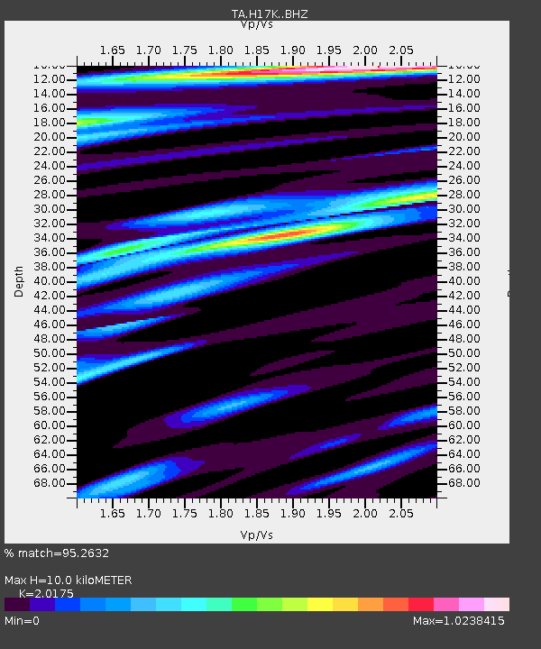
H17K Granite Mountain, AK, USA - Earthquake Result Viewer
| Earthquake location: |
Minahassa Peninsula, Sulawesi |
| Earthquake latitude/longitude: |
-0.2/119.8 |
| Earthquake time(UTC): |
2018/09/28 (271) 10:02:43 GMT |
| Earthquake Depth: |
10 km |
| Earthquake Magnitude: |
7.5 Mww |
| Earthquake Catalog/Contributor: |
NEIC PDE/us |
|
| Network: |
TA USArray Transportable Network (new EarthScope stations) |
| Station: |
H17K Granite Mountain, AK, USA |
| Lat/Lon: |
64.94 N/159.91 W |
| Elevation: |
396 m |
|
| Distance: |
86.0 deg |
| Az: |
24.886 deg |
| Baz: |
261.086 deg |
| Ray Param: |
0.04434665 |
| Estimated Moho Depth: |
10.0 km |
| Estimated Crust Vp/Vs: |
2.02 |
| Assumed Crust Vp: |
6.1 km/s |
| Estimated Crust Vs: |
3.024 km/s |
| Estimated Crust Poisson's Ratio: |
0.34 |
|
| Radial Match: |
95.2632 % |
| Radial Bump: |
400 |
| Transverse Match: |
83.49797 % |
| Transverse Bump: |
400 |
| SOD ConfigId: |
13570011 |
| Insert Time: |
2019-05-01 08:52:03.490 +0000 |
| GWidth: |
2.5 |
| Max Bumps: |
400 |
| Tol: |
0.001 |
|

Signal To Noise
| Channel | StoN | STA | LTA |
| TA:H17K: :BHZ:20180928T10:14:52.550007Z | 12.41479 | 1.8843823E-6 | 1.5178527E-7 |
| TA:H17K: :BHN:20180928T10:14:52.550007Z | 0.95485437 | 2.1330385E-7 | 2.2338888E-7 |
| TA:H17K: :BHE:20180928T10:14:52.550007Z | 3.9240487 | 6.281003E-7 | 1.6006435E-7 |
| Arrivals |
| Ps | 1.7 SECOND |
| PpPs | 4.9 SECOND |
| PsPs/PpSs | 6.6 SECOND |


