You are here: Home > Network List > TA - USArray Transportable Network (new EarthScope stations) Stations List
> Station I27K Kandik River, AK, USA > Earthquake Result Viewer
I27K Kandik River, AK, USA - Earthquake Result Viewer
| Earthquake location: |
Minahassa Peninsula, Sulawesi |
| Earthquake latitude/longitude: |
-0.2/119.8 |
| Earthquake time(UTC): |
2018/09/28 (271) 10:02:43 GMT |
| Earthquake Depth: |
10 km |
| Earthquake Magnitude: |
7.5 Mww |
| Earthquake Catalog/Contributor: |
NEIC PDE/us |
|
| Network: |
TA USArray Transportable Network (new EarthScope stations) |
| Station: |
I27K Kandik River, AK, USA |
| Lat/Lon: |
65.60 N/141.62 W |
| Elevation: |
874 m |
|
| Distance: |
93.7 deg |
| Az: |
24.305 deg |
| Baz: |
277.71 deg |
| Ray Param: |
0.041209035 |
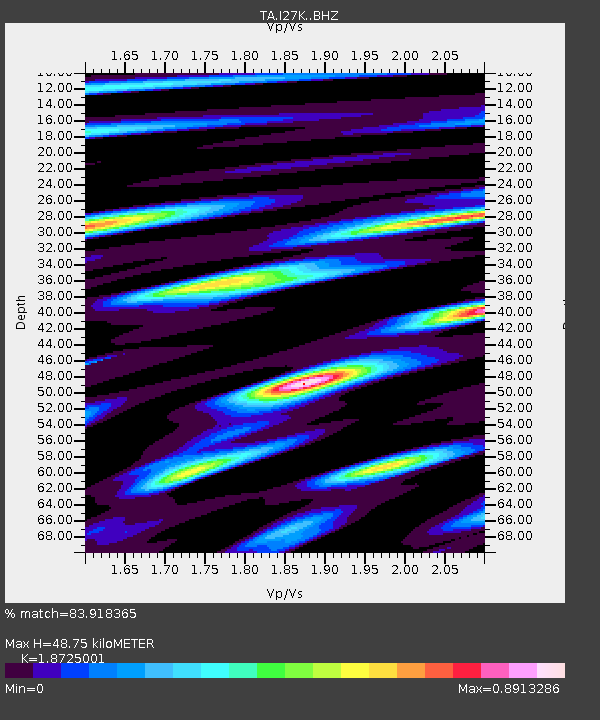
| Estimated Moho Depth: |
48.75 km |
| Estimated Crust Vp/Vs: |
1.87 |
| Assumed Crust Vp: |
6.566 km/s |
| Estimated Crust Vs: |
3.507 km/s |
| Estimated Crust Poisson's Ratio: |
0.30 |
|
| Radial Match: |
83.918365 % |
| Radial Bump: |
400 |
| Transverse Match: |
79.45541 % |
| Transverse Bump: |
400 |
| SOD ConfigId: |
13570011 |
| Insert Time: |
2019-05-01 08:52:16.209 +0000 |
| GWidth: |
2.5 |
| Max Bumps: |
400 |
| Tol: |
0.001 |
|

Signal To Noise
| Channel | StoN | STA | LTA |
| TA:I27K: :BHZ:20180928T10:15:28.550007Z | 3.7219472 | 1.1275794E-6 | 3.0295416E-7 |
| TA:I27K: :BHN:20180928T10:15:28.550007Z | 1.6971254 | 2.3010129E-7 | 1.3558297E-7 |
| TA:I27K: :BHE:20180928T10:15:28.550007Z | 1.8106213 | 6.609594E-7 | 3.6504565E-7 |
| Arrivals |
| Ps | 6.6 SECOND |
| PpPs | 21 SECOND |
| PsPs/PpSs | 28 SECOND |


