You are here: Home > Network List > TA - USArray Transportable Network (new EarthScope stations) Stations List
> Station U15A North Rim, AZ, USA > Earthquake Result Viewer
U15A North Rim, AZ, USA - Earthquake Result Viewer
| Earthquake location: |
Tonga Islands |
| Earthquake latitude/longitude: |
-20.8/-174.3 |
| Earthquake time(UTC): |
2009/07/30 (211) 20:05:34 GMT |
| Earthquake Depth: |
10 km |
| Earthquake Magnitude: |
5.9 MB, 5.7 MS, 5.8 MW, 5.7 MW |
| Earthquake Catalog/Contributor: |
WHDF/NEIC |
|
| Network: |
TA USArray Transportable Network (new EarthScope stations) |
| Station: |
U15A North Rim, AZ, USA |
| Lat/Lon: |
36.43 N/112.29 W |
| Elevation: |
2489 m |
|
| Distance: |
81.6 deg |
| Az: |
46.013 deg |
| Baz: |
236.554 deg |
| Ray Param: |
0.047445245 |
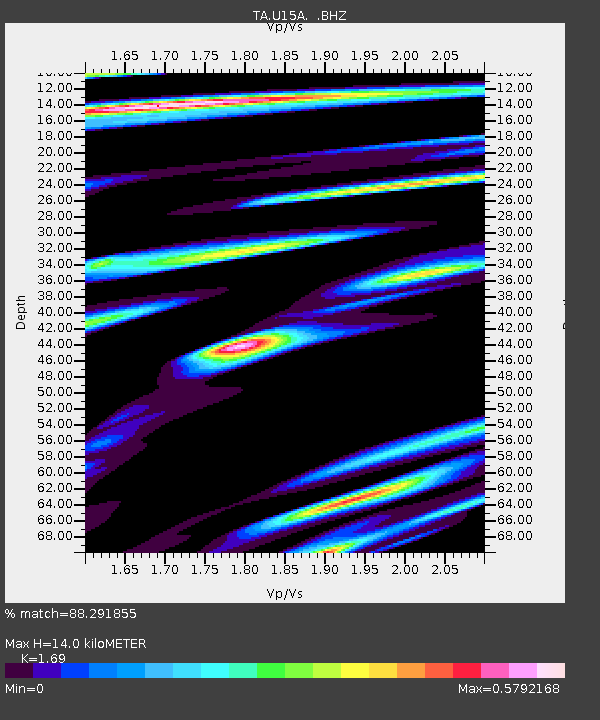
| Estimated Moho Depth: |
14.0 km |
| Estimated Crust Vp/Vs: |
1.69 |
| Assumed Crust Vp: |
6.194 km/s |
| Estimated Crust Vs: |
3.665 km/s |
| Estimated Crust Poisson's Ratio: |
0.23 |
|
| Radial Match: |
88.291855 % |
| Radial Bump: |
400 |
| Transverse Match: |
65.08479 % |
| Transverse Bump: |
400 |
| SOD ConfigId: |
2622 |
| Insert Time: |
2010-03-06 16:19:11.740 +0000 |
| GWidth: |
2.5 |
| Max Bumps: |
400 |
| Tol: |
0.001 |
|

Signal To Noise
| Channel | StoN | STA | LTA |
| TA:U15A: :BHZ:20090730T20:17:21.724009Z | 7.4791007 | 5.7237884E-7 | 7.653043E-8 |
| TA:U15A: :BHN:20090730T20:17:21.724009Z | 2.3787453 | 1.2293224E-7 | 5.167944E-8 |
| TA:U15A: :BHE:20090730T20:17:21.724009Z | 2.8401864 | 1.9601966E-7 | 6.901648E-8 |
| Arrivals |
| Ps | 1.6 SECOND |
| PpPs | 5.9 SECOND |
| PsPs/PpSs | 7.5 SECOND |


