You are here: Home > Network List > TA - USArray Transportable Network (new EarthScope stations) Stations List
> Station L27K Beaver Creek, Northway Junction, AK, USA > Earthquake Result Viewer
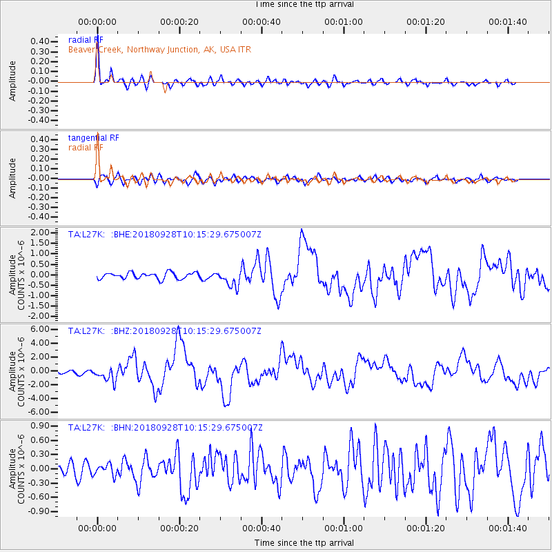
L27K Beaver Creek, Northway Junction, AK, USA - Earthquake Result Viewer
| Earthquake location: |
Minahassa Peninsula, Sulawesi |
| Earthquake latitude/longitude: |
-0.2/119.8 |
| Earthquake time(UTC): |
2018/09/28 (271) 10:02:43 GMT |
| Earthquake Depth: |
10 km |
| Earthquake Magnitude: |
7.5 Mww |
| Earthquake Catalog/Contributor: |
NEIC PDE/us |
|
| Network: |
TA USArray Transportable Network (new EarthScope stations) |
| Station: |
L27K Beaver Creek, Northway Junction, AK, USA |
| Lat/Lon: |
63.06 N/141.83 W |
| Elevation: |
755 m |
|
| Distance: |
93.9 deg |
| Az: |
26.854 deg |
| Baz: |
277.349 deg |
| Ray Param: |
0.04115829 |
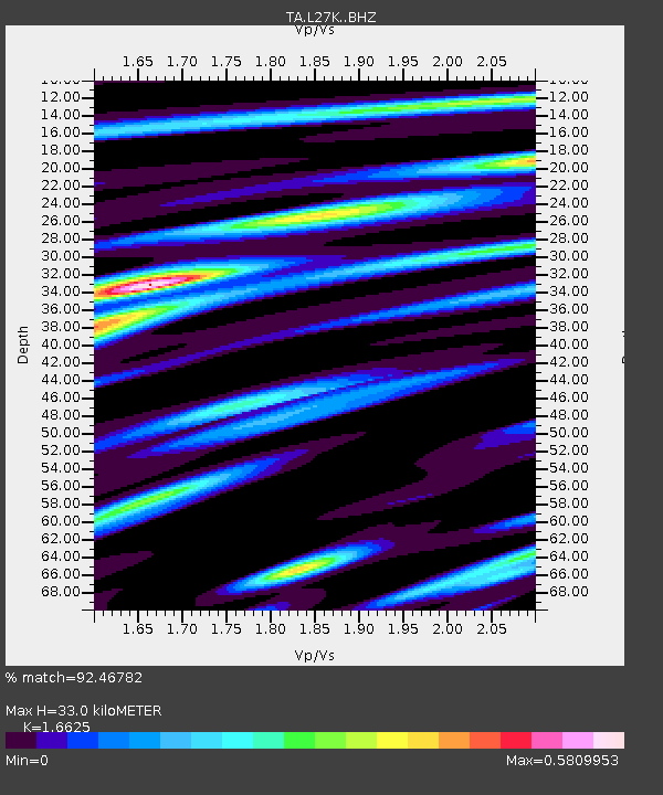
| Estimated Moho Depth: |
33.0 km |
| Estimated Crust Vp/Vs: |
1.66 |
| Assumed Crust Vp: |
6.566 km/s |
| Estimated Crust Vs: |
3.95 km/s |
| Estimated Crust Poisson's Ratio: |
0.22 |
|
| Radial Match: |
92.46782 % |
| Radial Bump: |
400 |
| Transverse Match: |
76.53106 % |
| Transverse Bump: |
400 |
| SOD ConfigId: |
13570011 |
| Insert Time: |
2019-05-01 08:52:36.842 +0000 |
| GWidth: |
2.5 |
| Max Bumps: |
400 |
| Tol: |
0.001 |
|
Signal To Noise
| Channel | StoN | STA | LTA |
| TA:L27K: :BHZ:20180928T10:15:29.675007Z | 5.9889984 | 1.0089072E-6 | 1.6846009E-7 |
| TA:L27K: :BHN:20180928T10:15:29.675007Z | 0.6815084 | 1.1578737E-7 | 1.6989867E-7 |
| TA:L27K: :BHE:20180928T10:15:29.675007Z | 2.626766 | 3.991094E-7 | 1.5193946E-7 |
| Arrivals |
| Ps | 3.4 SECOND |
| PpPs | 13 SECOND |
| PsPs/PpSs | 16 SECOND |


