You are here: Home > Network List > TA - USArray Transportable Network (new EarthScope stations) Stations List
> Station N16K Nishlik Lake, AK, USA > Earthquake Result Viewer
N16K Nishlik Lake, AK, USA - Earthquake Result Viewer
| Earthquake location: |
Minahassa Peninsula, Sulawesi |
| Earthquake latitude/longitude: |
-0.2/119.8 |
| Earthquake time(UTC): |
2018/09/28 (271) 10:02:43 GMT |
| Earthquake Depth: |
10 km |
| Earthquake Magnitude: |
7.5 Mww |
| Earthquake Catalog/Contributor: |
NEIC PDE/us |
|
| Network: |
TA USArray Transportable Network (new EarthScope stations) |
| Station: |
N16K Nishlik Lake, AK, USA |
| Lat/Lon: |
60.47 N/158.77 W |
| Elevation: |
582 m |
|
| Distance: |
85.9 deg |
| Az: |
29.406 deg |
| Baz: |
262.42 deg |
| Ray Param: |
0.044432335 |
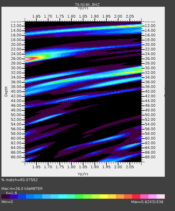
| Estimated Moho Depth: |
26.0 km |
| Estimated Crust Vp/Vs: |
1.60 |
| Assumed Crust Vp: |
6.276 km/s |
| Estimated Crust Vs: |
3.922 km/s |
| Estimated Crust Poisson's Ratio: |
0.18 |
|
| Radial Match: |
90.07552 % |
| Radial Bump: |
367 |
| Transverse Match: |
73.80924 % |
| Transverse Bump: |
400 |
| SOD ConfigId: |
13570011 |
| Insert Time: |
2019-05-01 08:52:56.016 +0000 |
| GWidth: |
2.5 |
| Max Bumps: |
400 |
| Tol: |
0.001 |
|

Signal To Noise
| Channel | StoN | STA | LTA |
| TA:N16K: :BHZ:20180928T10:14:51.949971Z | 3.3846211 | 1.806857E-6 | 5.338432E-7 |
| TA:N16K: :BHN:20180928T10:14:51.949971Z | 1.8844135 | 5.035571E-7 | 2.6722222E-7 |
| TA:N16K: :BHE:20180928T10:14:51.949971Z | 1.6544583 | 7.385253E-7 | 4.4638495E-7 |
| Arrivals |
| Ps | 2.5 SECOND |
| PpPs | 11 SECOND |
| PsPs/PpSs | 13 SECOND |


