You are here: Home > Network List > TA - USArray Transportable Network (new EarthScope stations) Stations List
> Station O14K Tigyukauivet Mountain, AK, USA > Earthquake Result Viewer
O14K Tigyukauivet Mountain, AK, USA - Earthquake Result Viewer
| Earthquake location: |
Minahassa Peninsula, Sulawesi |
| Earthquake latitude/longitude: |
-0.2/119.8 |
| Earthquake time(UTC): |
2018/09/28 (271) 10:02:43 GMT |
| Earthquake Depth: |
10 km |
| Earthquake Magnitude: |
7.5 Mww |
| Earthquake Catalog/Contributor: |
NEIC PDE/us |
|
| Network: |
TA USArray Transportable Network (new EarthScope stations) |
| Station: |
O14K Tigyukauivet Mountain, AK, USA |
| Lat/Lon: |
59.25 N/161.26 W |
| Elevation: |
129 m |
|
| Distance: |
84.5 deg |
| Az: |
30.432 deg |
| Baz: |
260.352 deg |
| Ray Param: |
0.04545737 |
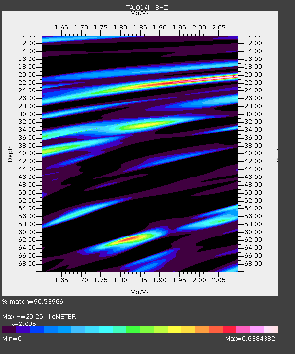
| Estimated Moho Depth: |
20.25 km |
| Estimated Crust Vp/Vs: |
2.09 |
| Assumed Crust Vp: |
6.24 km/s |
| Estimated Crust Vs: |
2.993 km/s |
| Estimated Crust Poisson's Ratio: |
0.35 |
|
| Radial Match: |
90.53966 % |
| Radial Bump: |
400 |
| Transverse Match: |
78.24544 % |
| Transverse Bump: |
400 |
| SOD ConfigId: |
13570011 |
| Insert Time: |
2019-05-01 08:53:01.345 +0000 |
| GWidth: |
2.5 |
| Max Bumps: |
400 |
| Tol: |
0.001 |
|

Signal To Noise
| Channel | StoN | STA | LTA |
| TA:O14K: :BHZ:20180928T10:14:44.849995Z | 6.1530833 | 2.7503258E-6 | 4.4698336E-7 |
| TA:O14K: :BHN:20180928T10:14:44.849995Z | 1.8221366 | 7.55092E-7 | 4.143992E-7 |
| TA:O14K: :BHE:20180928T10:14:44.849995Z | 1.9658378 | 8.2100826E-7 | 4.1763784E-7 |
| Arrivals |
| Ps | 3.6 SECOND |
| PpPs | 9.8 SECOND |
| PsPs/PpSs | 13 SECOND |


