You are here: Home > Network List > TA - USArray Transportable Network (new EarthScope stations) Stations List
> Station O15K Ungalikthiuk River, AK, USA > Earthquake Result Viewer
O15K Ungalikthiuk River, AK, USA - Earthquake Result Viewer
| Earthquake location: |
Minahassa Peninsula, Sulawesi |
| Earthquake latitude/longitude: |
-0.2/119.8 |
| Earthquake time(UTC): |
2018/09/28 (271) 10:02:43 GMT |
| Earthquake Depth: |
10 km |
| Earthquake Magnitude: |
7.5 Mww |
| Earthquake Catalog/Contributor: |
NEIC PDE/us |
|
| Network: |
TA USArray Transportable Network (new EarthScope stations) |
| Station: |
O15K Ungalikthiuk River, AK, USA |
| Lat/Lon: |
59.18 N/159.82 W |
| Elevation: |
306 m |
|
| Distance: |
85.2 deg |
| Az: |
30.625 deg |
| Baz: |
261.604 deg |
| Ray Param: |
0.044940405 |
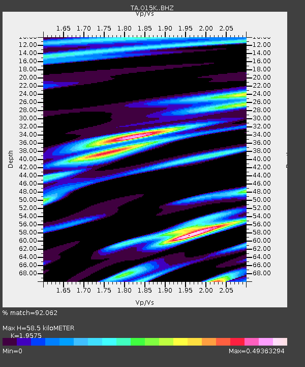
| Estimated Moho Depth: |
58.5 km |
| Estimated Crust Vp/Vs: |
1.96 |
| Assumed Crust Vp: |
6.24 km/s |
| Estimated Crust Vs: |
3.188 km/s |
| Estimated Crust Poisson's Ratio: |
0.32 |
|
| Radial Match: |
92.062 % |
| Radial Bump: |
400 |
| Transverse Match: |
74.83327 % |
| Transverse Bump: |
400 |
| SOD ConfigId: |
13570011 |
| Insert Time: |
2019-05-01 08:53:02.117 +0000 |
| GWidth: |
2.5 |
| Max Bumps: |
400 |
| Tol: |
0.001 |
|

Signal To Noise
| Channel | StoN | STA | LTA |
| TA:O15K: :BHZ:20180928T10:14:48.449971Z | 7.3117704 | 2.0986424E-6 | 2.870225E-7 |
| TA:O15K: :BHN:20180928T10:14:48.449971Z | 1.1614342 | 4.45805E-7 | 3.8384007E-7 |
| TA:O15K: :BHE:20180928T10:14:48.449971Z | 2.2591848 | 7.653337E-7 | 3.3876543E-7 |
| Arrivals |
| Ps | 9.2 SECOND |
| PpPs | 27 SECOND |
| PsPs/PpSs | 36 SECOND |


