You are here: Home > Network List > TA - USArray Transportable Network (new EarthScope stations) Stations List
> Station O17K Koliganek, Bristol Bay, AK, USA > Earthquake Result Viewer
O17K Koliganek, Bristol Bay, AK, USA - Earthquake Result Viewer
| Earthquake location: |
Minahassa Peninsula, Sulawesi |
| Earthquake latitude/longitude: |
-0.2/119.8 |
| Earthquake time(UTC): |
2018/09/28 (271) 10:02:43 GMT |
| Earthquake Depth: |
10 km |
| Earthquake Magnitude: |
7.5 Mww |
| Earthquake Catalog/Contributor: |
NEIC PDE/us |
|
| Network: |
TA USArray Transportable Network (new EarthScope stations) |
| Station: |
O17K Koliganek, Bristol Bay, AK, USA |
| Lat/Lon: |
59.77 N/157.09 W |
| Elevation: |
156 m |
|
| Distance: |
86.7 deg |
| Az: |
30.206 deg |
| Baz: |
263.922 deg |
| Ray Param: |
0.04389734 |
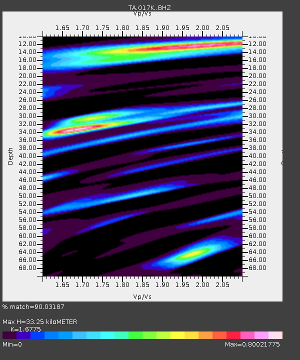
| Estimated Moho Depth: |
33.25 km |
| Estimated Crust Vp/Vs: |
1.68 |
| Assumed Crust Vp: |
6.276 km/s |
| Estimated Crust Vs: |
3.741 km/s |
| Estimated Crust Poisson's Ratio: |
0.22 |
|
| Radial Match: |
90.03187 % |
| Radial Bump: |
400 |
| Transverse Match: |
75.48069 % |
| Transverse Bump: |
400 |
| SOD ConfigId: |
13570011 |
| Insert Time: |
2019-05-01 08:53:03.432 +0000 |
| GWidth: |
2.5 |
| Max Bumps: |
400 |
| Tol: |
0.001 |
|
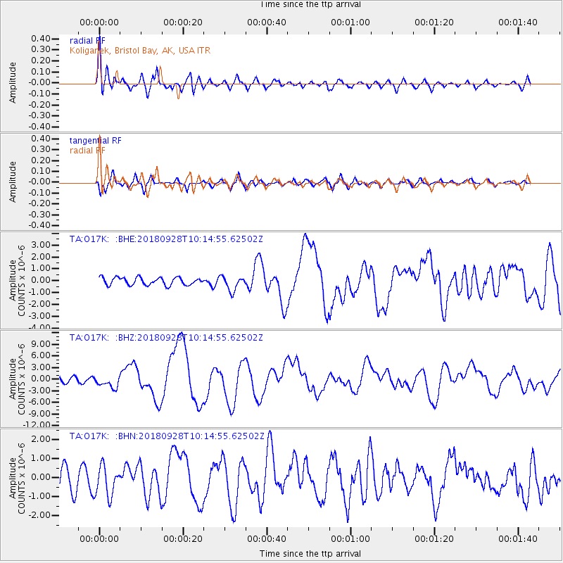
Signal To Noise
| Channel | StoN | STA | LTA |
| TA:O17K: :BHZ:20180928T10:14:55.62502Z | 2.4338796 | 1.6065414E-6 | 6.6007436E-7 |
| TA:O17K: :BHN:20180928T10:14:55.62502Z | 1.7782199 | 7.774789E-7 | 4.3722312E-7 |
| TA:O17K: :BHE:20180928T10:14:55.62502Z | 1.9826528 | 6.271823E-7 | 3.1633493E-7 |
| Arrivals |
| Ps | 3.7 SECOND |
| PpPs | 14 SECOND |
| PsPs/PpSs | 18 SECOND |


