You are here: Home > Network List > TA - USArray Transportable Network (new EarthScope stations) Stations List
> Station O16K Kokwok River, Bristol Bay, AK, USA > Earthquake Result Viewer
O16K Kokwok River, Bristol Bay, AK, USA - Earthquake Result Viewer
| Earthquake location: |
Minahassa Peninsula, Sulawesi |
| Earthquake latitude/longitude: |
-0.2/119.8 |
| Earthquake time(UTC): |
2018/09/28 (271) 10:02:43 GMT |
| Earthquake Depth: |
10 km |
| Earthquake Magnitude: |
7.5 Mww |
| Earthquake Catalog/Contributor: |
NEIC PDE/us |
|
| Network: |
TA USArray Transportable Network (new EarthScope stations) |
| Station: |
O16K Kokwok River, Bristol Bay, AK, USA |
| Lat/Lon: |
59.59 N/158.09 W |
| Elevation: |
198 m |
|
| Distance: |
86.1 deg |
| Az: |
30.328 deg |
| Baz: |
263.069 deg |
| Ray Param: |
0.04427272 |
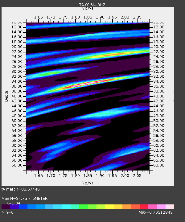
| Estimated Moho Depth: |
34.75 km |
| Estimated Crust Vp/Vs: |
1.84 |
| Assumed Crust Vp: |
6.24 km/s |
| Estimated Crust Vs: |
3.391 km/s |
| Estimated Crust Poisson's Ratio: |
0.29 |
|
| Radial Match: |
88.67446 % |
| Radial Bump: |
400 |
| Transverse Match: |
79.56517 % |
| Transverse Bump: |
400 |
| SOD ConfigId: |
13570011 |
| Insert Time: |
2019-05-01 08:53:03.539 +0000 |
| GWidth: |
2.5 |
| Max Bumps: |
400 |
| Tol: |
0.001 |
|

Signal To Noise
| Channel | StoN | STA | LTA |
| TA:O16K: :BHZ:20180928T10:14:53.074971Z | 2.8508785 | 1.7301801E-6 | 6.0689365E-7 |
| TA:O16K: :BHN:20180928T10:14:53.074971Z | 0.7033971 | 3.770991E-7 | 5.3611126E-7 |
| TA:O16K: :BHE:20180928T10:14:53.074971Z | 1.6312662 | 7.976625E-7 | 4.8898363E-7 |
| Arrivals |
| Ps | 4.8 SECOND |
| PpPs | 15 SECOND |
| PsPs/PpSs | 20 SECOND |


